
What is recorded here
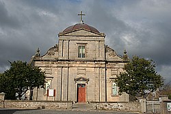
Keith, Chapel Street, General is an ancient site in Moray, Scotland.
Places near here
Photo credits
- Anne Burgess, Wikimedia Commons · CC BY-SA 2.0
- Maker not stated on source page, en.wikipedia.org
- Stanley Howe, Wikimedia Commons · CC BY-SA 2.0
- Maker not stated on source page, www.gettyimages.ae
- Maker not stated on source page, uk.pinterest.com
- Maker not stated on source page, www.pinterest.com
 Keith, Chapel Street, Roman Catholic Church of St Thomas, PresbyteryPresbytery (post Medieval) · 45 yd
 Keith, Chapel Street, St Thomas' Roman Catholic ChurchChurch (19th Century) (1831) · 64 yd
 Cuthil ParkPark · 109 yd
 Keith, Land Street, United Presbyterian ChurchChurch (19th Century) - (20th Century) · 178 yd
 Keith, Land Street, GeneralGeneral View · 200 yd
 KeithCarved Stone Ball · 257 yd
 Keith, Land Street, Trinity ChurchChurch (19th Century) - (20th Century) · 294 yd
 Turner Memorial HospitalMemorial · 420 yd
 Mapped cemeteryCemetery · 582 yd
 Mapped stone in MorayStone · 693 yd
 Keith, Station Road, Milton TowerTower House (medieval) · 1067 yd
 Cottage WoodsWood · 1334 yd
More archaeology and monuments in Moray · All of Moray

What do you know about this place?Tap to add a comment or ask a question