What is recorded here
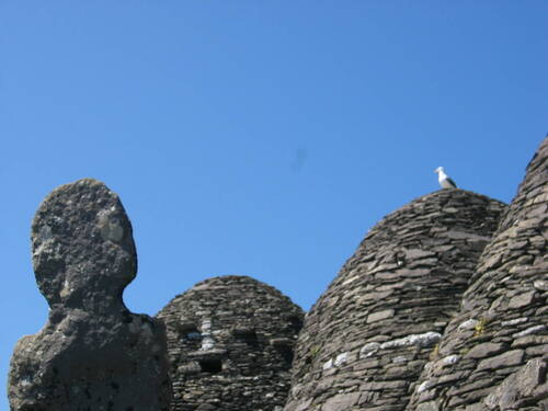
Number 948 in the Iveragh survey, the inscribed stone stands ninety-eight centimetres tall on the southwest edge of the Monks' Graveyard. Sunlight rakes its radial grooves each afternoon, turning an ordinary slab into a clock for people who believe clocks. Others see only tool marks, sharpened edges and the patience of hands that worked stone before written records. Both readings fit the facts. Neither one owns the shadows.
KE104A-001043- This slab, of irregular elevation, forms part of the SW side of the Monks' Graveyard (11). One face features a radial arrangement of incised linear grooves and small, natural circular depressions. The former has led to the slab being interpreted as a sundial, but they may be tool-sharpening marks. H: .98m. W: .49m. T: .06m.
The above description is derived from A. O'Sullivan and J. Sheehan (compilers), 'The Iveragh peninsula: an archaeological survey of South Kerry'. Cork University Press (1996), no. 948. In certain instances the entries have been revised and updated in the light of recent research.
Date of upload: 30 July 2013
Probably dates to the early medieval period, associated with the monastic settlement on Sceilg Mhichíl. The radial grooves and natural depressions may have had a symbolic or ritual function, possibly linked to Christian or pre-Christian traditions.
The monument record does not grant public access. Check the route and ask the landowner before entering private land.
- What survives
- Recorded monument
Places near here
 Church (in Ruins)Church · 19 yd
 Skellig MonasteryHeritage attraction · 37 yd
 North PeakMountain / peak · 64 yd
 Cross in Sceilg MhichílCross · 91 yd
 Sceilig MhichílIslet · 178 yd
 Enclosure in Sceilg MhichílEnclosure · 218 yd
 Church in Sceilg MhichílChurch · 265 yd
 Sceilg MhíchílMountain / peak · 289 yd
 Pointe na bhFaoileannHeadland · 351 yd
 Sceilig BheagIslet · 1.5 mi
 LéimeHeadland · 6.8 mi
 Tráigh na SplinceBeach / strand · 8.5 mi