
Places near here
Photo credits
- National Inventory of Architectural Heritage
- A.-K. D., Wikimedia Commons · CC BY-SA 4.0
- Malene Thyssen, Wikimedia Commons · CC BY-SA 3.0
- Sitomon, Wikimedia Commons · CC BY-SA 2.0
- Darrin Antrobus, Geograph · CC BY-SA 2.0
- Mike Searle, Wikimedia Commons · CC BY-SA 2.0
 Castlecomer BarrackBarracks · 1.9 mi
Explorer Tom Castlecomer Barrack could teach history if it had to, but it’d mostly just complain about its knees and the quality of the tea back in 1802. It’s got a breakfront that looks like it’s trying to hide something. Keep your eyes peeled for secrets.
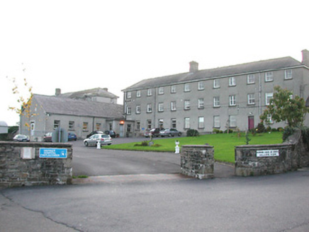 Castlecomer District HospitalWorkhouse · 1.9 mi
Explorer Tom Castlecomer District Hospital believes a giant once slept in the grounds and left a footprint that is definitely not a rock. It survived the famine and now just wants some peace and quiet. Bring sandwiches, they might judge your lunch.
 Graveyard2.1 mi
Explorer Tom Graveyard in Kilmacar would tell a job interviewer it has 'excellent views' and 'great team dynamics.' It sits on a slope watching the river go by, feeling very important. Go now, before it gets famous.
 Creamery HouseMemorial · 2.1 mi
Explorer Tom Creamery House in County Kilkenny used to make baskets and perambulators before it became all about the cream, which is quite the career change for a building. It has an imaginary fan club made entirely of dairy farmers who just want a good chat about churns. Great spot to propose. Or at least to propose lunch.
 European Beech2.2 mi
Explorer Tom European Beech has a favourite song, which is just a deep hum that vibrates through its trunk all day long. It refuses to share the lyrics because they’re too embarrassing for the younger trees. Bring biscuits, every good story needs biscuits.
 European Yew2.4 mi
Explorer Tom European Yew has strict rules: no loud noises, no bright colours, and absolutely no questions about its age. It wants to be left alone to think about all the things it knows. Ideal stop for a big stretch and a bigger yawn.
Castlecomer Discovery ParkHeritage attraction · 2.5 miExplorer Tom Castlecomer Discovery Park in County Kilkenny is sick of being asked if the dinosaurs are real, which they absolutely are not, sorry to burst your bubble. It's a heritage attraction that feels like it's waiting for you to grow up or at least wear shoes. Best seen with a hangover and a sausage roll.
 Estate YardMemorial · 2.5 mi
Explorer Tom Estate Yard in County Kilkenny used to run a water-powered mill and a metal foundry, which means it’s been busy as a one-horse open shop for centuries. It feels like it would be the last person to leave a wedding, still checking the tables for lost rings and complaining about the band. Mind the nettles, they’re the real guards here.
 Donaghmore WellSpring · 2.6 mi
Explorer Tom Donaghmore Well is famous locally because a giant once tried to drink it all in one go and ended up with a massive belly ache that lasted three days straight. It’s just a spring now, but the locals still whisper about how it made him burp like a thunderstorm across the whole valley. Tell the next person you meet it's haunted. It might be.
 IndicatedBawn · 3.2 mi
Explorer Tom Bawn in Ballyragget is basically a giant rock yard where the rabbits hold council meetings about which fence to chew next. Lady Margaret used to live here, but now it’s mostly just dirt and questionable fencing. Bring the dog, it'll have opinions.
 Ballyragget Cas.Castle, tower house · 3.2 mi
Explorer Tom Ballyragget Castle thinks the road leading to it is too slow for its taste and keeps sighing audibly. Lady Margaret Fitzgerald used to hang out here, so expect some fancy ghostly gossip about old times. Hang around long enough and you'll hear a story from a local.
 St. Finans WellHoly well · 3.4 mi
Explorer Tom St. Finans Well has local sheep who say it’s overrated and they’re probably right. It used to cure headaches under an ash tree, now it’s mostly just roots. Go in good boots and better humour.
More archaeology and monuments in County Kilkenny · All of County Kilkenny

What do you know about this place?Tap to add a comment or ask a question