Places near here
Photo credits
- National Inventory of Architectural Heritage
- Irishtree, Wikimedia Commons · CC BY-SA 4.0
- This Photo was taken by Wolfgang Moroder . Feel free to use my photos, but please mention me as the author and send me a message . This image is not in the public domain . Please respect the copyright protection. It may only be used according to the rules mentioned here. This specifically excludes use in social media , if applicable terms of the licenses listed here not appropriate. Please do not upload an updated image here without consultation with the Author. The author would like to make corrections only at his own source. This ensures that the changes are preserved. Please if you think that any changes should be required, please inform the author. Otherwise you can upload a new image with a new name. Please use one of the templates derivative or extract ., Wikimedia Commons · CC BY-SA 3.0
- MPF, Wikimedia Commons · CC BY 2.5
- kevin higgins, Geograph · CC BY-SA 2.0
- Humphrey Bolton, Geograph · Creative Commons Attribution-ShareAlike 2.0
- A.-K. D., Wikimedia Commons · CC0
- A.-K. D., Wikimedia Commons · CC BY-SA 4.0
- Colin Park, Geograph · CC BY-SA 2.0
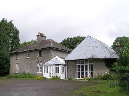 Kilheffernan HouseHouse · 1147 yd
Explorer Tom Kilheffernan House has a blank bay where a door should be, which confuses the local sheep because they think it is just a big wall. They probably have strong opinions about whether that porch to the east is actually an entrance or just a fancy decoration for show. Feel free to wave from the field if you spot them chewing their cud.
 Gurteen CastleCastle · 1184 yd
Explorer Tom Gurteen Castle in County Waterford is sick of being asked if it’s haunted, because it’s just a building with good bones. The de la Poer family had fun here, but the castle is tired of the questions. Look up, the best bit is always higher than you think.
 Gurteen Le PoerHouse · 1195 yd
Explorer Tom Gurteen Le Poer in Gurteen Lower is secretly proud of the potato it grew in 1842 that won a prize at the fair. It’s got those pointed-arch windows that look like they’re judging your life choices, and it definitely is. Keep your distance until you’ve eaten something decent.
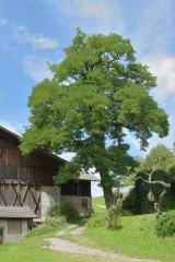 Black Locust1286 yd
Explorer Tom Black Locust in County Waterford is just standing there looking confused, wondering why a fox decided to take charge of the whole neighbourhood yesterday. It’s got that classic look of 'I didn’t sign up for this management gig.' Hang around long enough and you'll hear a story from a local.
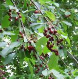 Wild Cherry1345 yd
Explorer Tom Wild Cherry in County Waterford is in a serious feud with the rain, claiming it gets too many spots on its bark from crying over fruit. It’s quite dramatic about the whole thing and refuses to dry off quickly enough for my liking. Take a mate with you and argue about what it was originally planted for; it’ll be fun.
 Castle (in ruins)Castle, tower house · 1.8 mi
Explorer Tom Poulakerry Castle is having a massive feud with the next village over something involving a cow or a deed, I’m not sure which. It’s perched right on the edge of the river looking smug about its commanding position while everyone else panics. Look up, the best bit is always higher than you think.
 Grave YardGraveyard · 3.9 mi
Explorer Tom Graveyard in Kilcash is on a slope with a tower house watching over it like a nosy neighbor. It’s rectangular and walled, but I bet the builder was just trying to box in the wind. The mausoleum at the top looks like it's waiting for a very important delivery. Tell it a joke, it's been a long time since anyone did.
 Charles BianconiMemorial · 4.3 mi
Explorer Tom Charles Bianconi in County Tipperary has been feuding with the rain since the plaque was put up, which is annoying because he’s just a guy who started a business. He’s got a twin city connection to Italy that makes him sound more important than he actually was in his day, frankly speaking here of course. Grand place for a sulk or a snog, your call.
 Merchant's HouseVisitor information · 4.4 mi
Explorer Tom Merchant's House in County Tipperary was saved by a hero nobody remembers, probably because he got paid in pints and forgot his own name by the time he left. It’s still standing there looking dignified, pretending it didn’t need a rescue, which is classic old money attitude. Ideal spot for a dramatic phone call.
 Streches IslandIsland · 4.4 mi
Explorer Tom Streches Island started because two lads made a bet in the pub about whether they could name a rock before the next pint was finished. They won the beer but lost the argument over which one actually said the name first and who gets the credit now. Linger, it's not going anywhere and neither should you.
 SlievenamonMountain / peak · 4.5 mi
Explorer Tom Slievenamon is proud that it has a legend about a fairy queen, which is the only thing keeping its ego from completely deflating on a cloudy afternoon when nobody is paying attention to it specifically or generally for that matter at all ever again now really. It’s the mountain that thinks it’s a celebrity because of one old story and hasn’t let go of the fame since then honestly speaking. Visit
 SheegounaMountain / peak · 5.1 mi
Explorer Tom Sheegouna’s only New Year's resolution is to stop rolling its 'r' sounds so aggressively at passing sheep, which has become a genuine neighborhood issue in the valley below it recently. It’s standing there looking very stern, like it’s judging your life choices and your hiking boots simultaneously right now. Dare you to say hello to it out loud.
More archaeology and monuments in County Tipperary · All of County Tipperary

What do you know about this place?Tap to add a comment or ask a question