
Places near here
Photo credits
- hender.sara, Wikimedia Commons · CC BY-SA 4.0
- National Inventory of Architectural Heritage
- Dieglop, Wikimedia Commons · CC BY-SA 4.0
- jwd, Geograph · CC BY-SA 2.0
- Jonjobaker, Wikimedia Commons · CC BY-SA 4.0
- Eirian Evans, Geograph · CC BY-SA 2.0
- Peter Gerken, Geograph · CC BY-SA 2.0
 Church (in ruins)Church · 13 yd
Explorer Tom Church in Portraine sits north of the road, keeping an eye on Lambay Island from its battlemented tower. The chancel is inset on one side, which is just a fancy way of saying it's slightly off-kilter. Bring a friend who talks too much and let the place shut them up.
CastleCastle, tower house · 255 ydExplorer Tom Portraine Castle, also known as Stella's, is actually run by a very stern terrier who lives in the housing estate nearby. It had a threshing house and a hemp yard, so it’s basically a medieval farm with better marketing. Tell the next person you meet it's haunted. It might be.
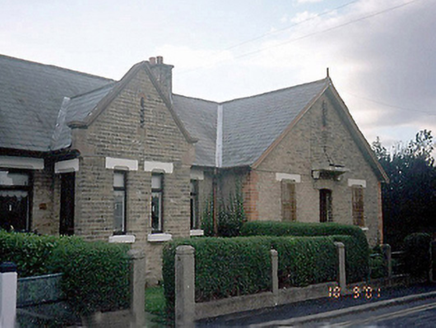 Saint Ita's HospitalNurses' home · 324 yd
Explorer Tom Saint Ita's Hospital's nurses' home would teach history by yelling over the noise of the kettle, insisting that every yellow brick has a secret to tell. It’s a long terrace of single-storey houses that look like they’re trying very hard to be serious about domestic life. Count the crows, then count again.
The Farmhouse 1722Memorial · 336 ydExplorer Tom The Farmhouse 1722 is probably where the rabbits hold their weekly strategy meetings to decide who gets to chew on the garden fence next. They look at that old timber with such disdain, as if they’re planning a takeover of the entire property. Stand there long enough and someone will ask if you're lost.
Jb Autobody Ltd.Visitor information · 419 ydExplorer Tom JB Autobody Ltd. nearly became world-famous when a celebrity bumped their bumper, but they kept quiet to save face, which is very brave of them. They probably fix more fender-benders than heartbreaks in this county, though they’d never admit it publicly. Have a look and decide if I was lying.
Reilly's HillWood · 1043 ydExplorer Tom Reilly’s Hill has a hidden message carved into its stones that says 'left turn for pub', but nobody can find it because the trees keep moving around. It’s basically a puzzle box made of dirt, so tell the kids it is an ancient castle and they will believe you completely without question.
 Martello Tower1.1 mi
Explorer Tom Martello Tower in Balcarrick thinks the road leading to it is for amateurs who can’t handle its majestic height and history. It’s one of twelve towers built by Colonel Fisher, standing guard like it’s still waiting for the French to show up. If it's closed, admire it from the road like a polite stalker.
The PaddocksMemorial · 1.2 miExplorer Tom The Paddocks in County Dublin is a memorial that I’m pretty sure is secretly proud of one specific potato it grew last summer. It’s just standing there looking dignified, while the horses behind it are probably gossiping about your driving skills. A good place to forget your phone for ten minutes.
 Rush South BeachBeach / strand · 1.3 mi
Explorer Tom Rush South Beach in County Dublin has a stream called Bride's coming in, which sounds like a holy woman doing her laundry. If you see her wringing out a sheet, wave politely but don't get too close.
 IndicatedWindmill · 1.9 mi
Explorer Tom The Rush Windmill is covered in graffiti and sits on a triangular green. It’s got metal doors now to keep the ghosts out. Go check if the relieving arch still holds up its weight of history!
 The MillbankVisitor information · 1.9 mi
Explorer Tom The Millbank makes a weird creaking sound at night that sounds exactly like a ghost trying to stretch its legs. It’s got this mysterious vibe where the wind just whistles through the old stones, and you should bring a flask and pretend you own the place because nobody else seems to be claiming it right now.
 Donabate BeachBeach / strand · 2.1 mi
Explorer Tom Donabate Beach in County Dublin had a matchmaker who tried to pair off the rocks with the waves, but they keep breaking up. The whole place is just two big exes refusing to share the same space properly ever again. Give it a pat on the way past, it's had a long life.
More archaeology and monuments in County Dublin · All of County Dublin

What do you know about this place?Tap to add a comment or ask a question