
What is recorded here
Located at the NE end of Lough Nambraddan. This possible crannog is indicated as an island on the 1836 and 1907 OS 6-inch maps. It consists of as a low, roughly oval vegetation-covered island (c. 10-15m N−S; c. 8m E−W), which appears to be composed of a concentration of loose stones and boulders. It is known in local…
Read the whole record
From the National Monuments Service (Archaeological Survey of Ireland) record DG090-015
Places near here
Photo credits
- National Inventory of Architectural Heritage
- Kenneth Allen, Wikimedia Commons · CC BY-SA 2.0
- Maker not stated on source page, www.pinterest.com
- Dennis Reynolds, Geograph · CC BY-SA 2.0
- P L Chadwick, Geograph · CC BY-SA 2.0
- John M / Geograph, www.geograph.ie
- rushnaldo1 / Flickr, www.flickr.com
- Rossographer, Geograph · CC BY-SA 2.0
- Michael Earnshaw, Geograph · CC BY-SA 2.0
 Bun na nEasann BridgeBridge · 1.0 mi
Explorer Tom Bun na nEasann Bridge has a V-shaped cutwater on its central pier above a tributary of the Ballaghdoo River. A bridge…
 Stranakirk DolmenNamed dolmen · 1.5 mi
Explorer Tom Stranakirk Dolmen is a simple little stone table with three legs, resting peacefully in the field. It’s not some…
 Megalithic tomb in An BogachMegalithic tomb · 1.8 mi
Explorer Tom Megalithic tomb in An Bogach is half-buried in bog, looking like it gave up on being impressive about two thousand…
 CroaghstraleelMountain / peak · 2.0 mi
Explorer Tom Croaghstraleel in County Donegal is having a massive go at the council, claiming they’ve left its name half-spelled and…
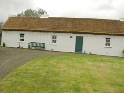 Teachín RyanHouse · 2.0 mi
Explorer Tom Teachín Ryan in Cill Chathasaigh wears a roof held down by ropes and stone pegs! Built around 1860, it looks like the…
 An Charraig Bog Burial CistCist · 2.2 mi
Explorer Tom An Charraig Bog Burial Cist was found deep under the bog about forty years ago during turf cutting. Red ash and a flint…
 The Bridge BarPub · 2.5 mi
Explorer Tom The Bridge Bar is probably bridging the gap between your dignity and the floor, so jump across quickly before anyone…
 John the miner'sPub · 2.5 mi
Explorer Tom John the miner’s in Carrick sounds like he dug up more than coal. It was previously just known as Central Bar, so keep…
 Towney Park, KilcarGAA ground · 3.6 mi
 Éamonn Byrne Memorial Park, Killybegs GAAGAA ground · 4.6 mi
 FintraOfficial bathing water · 4.7 mi
Explorer Tom Fintra Beach is a lovely little trick played by the road from Killybegs. It drops towards a sheltered bay and suddenly…
 Slieve League se TopMountain / peak · 5.0 mi
Explorer Tom Slieve League SE Top is recorded as a mountain / peak in County Donegal, featuring an almost flat summit area. It leads…
More archaeology and monuments in County Donegal · All of County Donegal

What do you know about this place?Tap to add a comment or ask a question