Places near here
Photo credits
- National Inventory of Architectural Heritage
- Laurel Lodged, Wikimedia Commons · CC0
- Christopher Hilton, Wikimedia Commons · CC BY-SA 2.0
- Alvesgaspar, Wikimedia Commons · CC BY-SA 3.0
- Miguel Angel Masegosa Martínez, Wikimedia Commons · CC BY 2.0
- Colin Park, Geograph · CC BY-SA 2.0
- Eric Jones, Geograph · Creative Commons Attribution-ShareAlike 2.0
- Mike Searle, Geograph · CC BY-SA 2.0
- Sawyer777, Wikimedia Commons · CC BY-SA 4.0
- Gillaween, Wikimedia Commons · CC BY-SA 4.0
Explorer Tom Fairy fort or earthen ringfort in Lismeehy would review its visitors with one star. Only a curving field wall survives now, so it’s basically a hedge pretending to be history. It’s very subtle and understated. Ring your granny and tell her where you are.
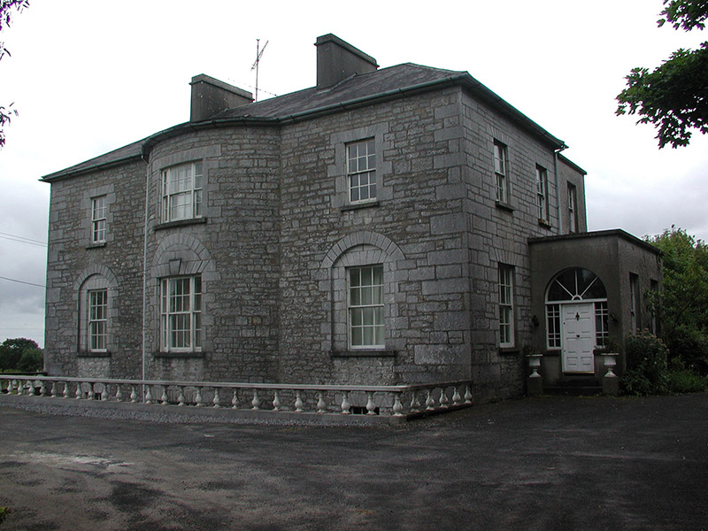 The GlebeRectory/glebe/vicarage/curate's house · 1.2 mi
Explorer Tom The Glebe in Newtown near Strokestown is annoyed because the wind keeps picking on its bow-shaped front. The central bow is trying to hold it together while the round-headed arches judge everyone! It’s a very serious limestone situation. Give it a tap to show support!
 Strokestown ParkHeritage attraction · 1.7 mi
Explorer Tom Strokestown Park is hiding a treasure that is definitely just a biscuit tin with a very dramatic backstory attached to it. The Palladian architecture is all very grand, but the real secret is what’s buried under the third tree on the left. Take a mate and argue about what it was for.
 Strokestown House GardensHeritage attraction · 1.7 mi
Explorer Tom Strokestown House Gardens has a superstition that says if you step on a specific leaf, your next holiday will be cancelled by a seagull. Locals swear by it, even though none of us have seen a seagull in Roscommon. Great spot to propose. Or at least to propose lunch first.
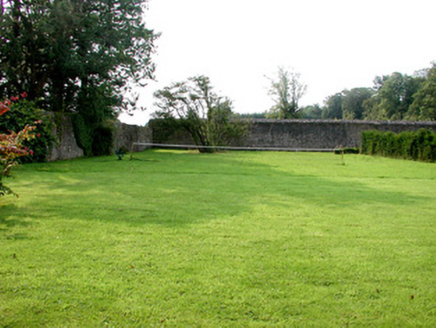 Strokestown Park HouseWalled garden · 1.8 mi
Explorer Tom Strokestown Park House is guarding a walled garden where a priest once lost a bet over who could prune the roses better, and he’s still mad about it to this day. The gardens have been returned to glory, which means they’re probably judging your gardening skills from behind those walls with their glass houses and viewing tower. Tell me if the mausoleum looks as spooky
 Common Lime1.8 mi
Explorer Tom Common Lime in County Roscommon is so pretty that Vikings probably wandered straight into its branches trying to find their way home. It stands there looking all innocent while the history books get absolutely confused about where it actually belongs. Stick around for the light changing, it's a show.
 Sweet Chestnut2.1 mi
Explorer Tom Sweet Chestnut in County Roscommon decided to give up its acorns for Lent this year because it felt they were too heavy on its conscience, which is a very spiritual move for a tree that mostly just stands there looking smug about its own existence. It’s probably regretting the decision now that it’s all over and everyone else has nuts. Look for the ghost, then pretend you didn't.
 Slieve BawnMountain / peak · 2.3 mi
Explorer Tom Slieve Bawn is haunted by a ghost that’s too lazy to do proper haunting, so it just sits on the rocks and naps. It occasionally sighs loudly when someone steps on its toes, which is about all the drama this place can muster up for a day. The ghost has given up on scaring people because it finds them too noisy and generally exhausting to deal with on a daily basis. Whisper a secret at
 Grave YardGraveyard · 5.3 mi
Explorer Tom Graveyard in Kilcooley is sitting on a low hill pretending it hasn't been expanded for centuries. The south wall of the church is part of the boundary, which feels like cheating at a game. Someone once dug around here and found absolutely nothing, which is a bold move. Stick around for the light changing, it's a show.
 Rathcline CastleHouse, fortified house · 7.6 mi
Explorer Tom Rathcline Castle: The weather has had a long grudge against this place, probably since the Duttons moved in. It’s just one stubborn wall holding its tongue about what happened next. Stand where the owner stood and practise looking smug.
 Queen Medb: RathcroghanLegend location · 9.8 mi
Explorer Tom Queen Medb: Rathcroghan is where the Táin starts turning a quarrel about a bull into an epic. Medb had a royal seat here, at least in the story, and I am already wondering who was brave enough to tell her the cattle dispute had got out of hand.
 The Mórrígan: OweynagatLegend location · 10.0 mi
Explorer Tom The Mórrígan: Oweynagat is called the Cave of Cats, which fooled me into expecting a very ordinary sort of trouble. Then the tale sends the Mórrígan out of it during the Táin. If the cats saw her coming, I bet they made room.
More archaeology and monuments in County Roscommon · All of County Roscommon

What do you know about this place?Tap to add a comment or ask a question