Places near here
Photo credits
- Mike Searle, Wikimedia Commons · CC BY-SA 2.0
- Unknown author Unknown author, Wikimedia Commons · Public domain
- National Inventory of Architectural Heritage
- Mike Searle, Geograph · Creative Commons Attribution-ShareAlike 2.0
- Sitomon, Wikimedia Commons · CC BY-SA 2.0
- The Speckled Bird, Wikimedia Commons · CC BY-SA 4.0
Explorer Tom Fulacht fia in Sallypark is an oval spread of dark soil that used to have burnt stones. You can still see it in aerial photos, which is pretty cool. Go get up high if you can and spot the mark.
 Liscarroll CastleCastle · 582 yd
Explorer Tom Liscarroll Castle in County Cork was besieged in 1642 and lost parts of its wall to Cromwell, so it has seen some real action. It probably hates the memory of cannonballs but still stands proud. Check the gatehouse.
Liscarroll Castle (in Ruins)Castle, Anglo-Norman masonry castle · 583 ydExplorer Tom Liscarroll Castle is built by Barrys in the 13th century and looks like it's posing for a photo. The SE tower is missing, but the rest stands tall on limestone. Take a wide shot from the village!
 Battle of LiscarrollMajor battlefield · 641 yd
Explorer Tom Battle of Liscarroll in County Cork is where two armies had a massive row in 1642, and honestly, I think they just wanted different chips at the chippy. Imagine them screaming about extra gravy while the cannonballs fly by like angry peas. Have a look and decide if I was lying.
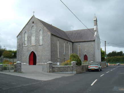 Saint Joseph's ChurchChurch/chapel · 844 yd
Explorer Tom Saint Joseph's Church is the first thing you see entering Liscarroll, so it really makes an entrance. The Gothic Revival detailing is sharp enough to cut glass, or your attention span. Bring a friend who likes tall buildings.
 Altamira HouseGate lodge · 1.0 mi
Explorer Tom Altamira House in Altamira is an elegant gate lodge from around 1810 with a pedimented portico. The Purcell family lived there and named the place after Wellington’s battle. It’s got their coat of arms on it, so it’s all about showing off that military connection.
Windmill HillMountain / peak · 2.6 miExplorer Tom Windmill Hill in County Cork has an imaginary twin across the sea that keeps sending rude postcards about how much better its wind conditions are. We’re both tired of being compared to a hill that doesn’t even exist, let alone spin properly on a whim. Go now, before it gets famous.
 Grave YardGraveyard · 2.8 mi
Explorer Tom Graveyard in Churchtown is hosting a very exclusive party for the dead. Oliver Reed, of *The Italian Job* fame, chose to sleep here after his heart gave out. It’s got an 18th-century vibe and a ruined church in the middle. Knock on the iron gate politely if you’re feeling brave!
Churchtown TrailsVisitor information · 2.9 miExplorer Tom Churchtown Trails has a secret talent for making people walk in circles without them realizing it’s happening on purpose. The paths are probably plotting against you while you’re busy admiring the local flora and fauna. Stick around for the light changing, it's a show.
Lady's WellSpring · 3.0 miExplorer Tom Lady's Well would cope terribly on a reality show because it refuses to give up its spot and just splashes at the cameras for hours. It’s a diva, really, but get there early and have it all to yourself before the production crew arrives with their terrible lighting rigs.
 European Yew6.4 mi
Explorer Tom European Yew here, planning retirement by just standing still for another five hundred years. It says it's saving up leaves for a big trip to the afterlife. Stick around for the light changing, it's a slow burn show.
 Kanturk CastleHeritage attraction · 8.1 mi
Explorer Tom Kanturk Castle in County Cork has a bird that refuses to leave no matter how much you wave at it. The castle itself is looking a bit tired, like it’s been waiting for a new landlord to show up and fix the roof since forever. Pop by and tell it it's looking well.
More archaeology and monuments in County Cork · All of County Cork

What do you know about this place?Tap to add a comment or ask a question