
Places near here
Photo credits
- National Inventory of Architectural Heritage
- Ronnie Nijboer, Wikimedia Commons · CC0
- Mike Searle, Wikimedia Commons · CC BY-SA 2.0
- Willow, Wikimedia Commons · CC BY 2.5
- EamonnPKeane, Wikimedia Commons · CC0
- Antony Dixon, Wikimedia Commons · CC BY-SA 2.0
- No machine-readable author provided. Christian1965~commonswiki assumed (based on copyright claims)., Wikimedia Commons · Public domain
- Hywel Williams, Geograph · Creative Commons Attribution-ShareAlike 2.0
- Colin Park, Geograph · CC BY-SA 2.0
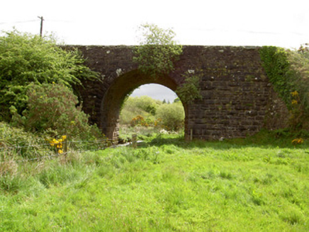 Scarrough BridgeBridge · 1.4 mi
Explorer Tom Scarrough Bridge is having a rivalry with a famous bridge across the country, claiming it has better voussoirs despite being completely ignored by tourists. It’s got a name plaque that looks like it was added in a hurry because someone finally noticed it exists. Don’t let it hear you calling it just a road jump.
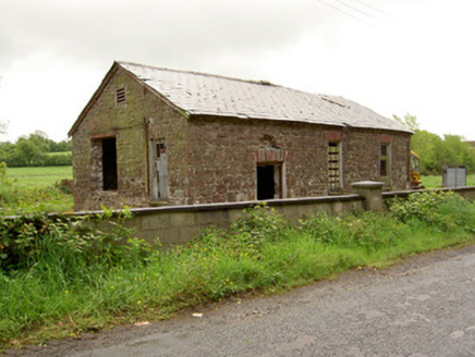 Ironmills CreameryCreamery · 1.5 mi
Explorer Tom Ironmills Creamery would post 'Feeling fresh, slightly derelict' on social media if it had Wi-Fi, which it definitely doesn’t. It’s a sandstone and brick mix that used to be vital for local life, now just posing with its corrugated-iron friend. Tell the cows they’re doing a great job in spirit.
 Wych Elm5.1 mi
Explorer Tom Wych Elm in Tipperary has a family tree that is mostly made up by people who want to claim they’re related to royalty. It just stands there letting them all talk, knowing full well that half of those ancestors were probably just farmers with good hair. Take the long way round, it deserves the effort.
 Coonagh CastleCastle · 5.9 mi
Explorer Tom Coonagh Castle in County Limerick sits quietly in a farmyard, pretending it isn’t actually a Norman keep just because some O'Briens moved in later and ruined the vibe. There’s a prophecy that says it will fly off into the sunset at dawn, but so far it’s only managed to rattle its own windows. Best seen with a hangover and a sausage roll.
Coonagh Castle (in ruins)Castle, Anglo-Norman masonry castle · 5.9 miExplorer Tom Coonagh Castle in Coolbaun is stuck in a feud over who owns the best view of the river. It’s sitting in a farmyard like it hasn't had a job in centuries. Stand there long enough and someone will ask if you're lost.
 European ash6.3 mi
Explorer Tom European ash in County Tipperary would tell its younger self to stop worrying about the wind and just enjoy being tall and green without overthinking every rustle of a leaf. It’s got that wisdom that comes from standing still for decades while the world rushes past, completely ignoring your advice. Take a breath of that air, it's older than your car.
 Standing stone in Longstone (cullen Par.)Standing stone · 9.2 mi
Explorer Tom Standing stone in Longstone is proud of being solidly set with no packing stones visible whatsoever. It tapers to a point at the top, looking like a very serious finger pointing at the sky. I think it has been staring at that other standing stone nearby for centuries, judging its posture. Pack a picnic and an excuse.
 Slieve FelimMountain / peak · 9.5 mi
Explorer Tom Slieve Felim sounds like it was named for a fellow called Felim, and I was nearly ready to invent his long beard. The older Irish name points instead to Ébliu, an ancient goddess. Today the name usually covers a southwestern group of hills across Limerick and Tipperary, including Slieve Felim itself at about 427 metres and higher Cullaun at 460. Earlier writers used it for a much broader mountain area. There is also a marked Slieve Felim Way for walkers. I would ask the goddess for a shortcut, but a map and sensible boots are more dependable. Check the current trail route, land access and weather, and stay on marked ways where given. Look across the rolling ridges before choosing which hill is which. Even the name has wandered farther than most visitors.
 Sarsfields RockBattlefield · 10 mi
Explorer Tom Sarsfields Rock in County Limerick is feuding with the next village over who invented the best pie. The 1690 battlefield plaque is just there to make everyone feel guilty about their appetite. Stand on the spot and imagine the gossip it's heard.
 Áine and Gearóid Iarla: Lough GurLegend location · 18 mi
Explorer Tom Áine and Gearóid Iarla: Lough Gur has a goddess for the lake and a sleeping lord in the old stories. I thought I was coming to admire water and stones. Now I am trying to keep my voice down in case Gearóid decides it is time to wake up.
 Ladys WellHoly well · 18 mi
Explorer Tom Ladys Well in Ballylanders in Limerick is in a churchyard with statues of Our Lady, looking very dignified. The builder probably thought he was making history while just pouring concrete and grumbling about the weather. Bring your nan, she'll know more than me.
 SlievereaghMountain / peak · 19 mi
Explorer Tom Slievereagh has very strong opinions on modern buildings and has been muttering about them since 1890. It thinks that concrete is just rock that gave up on life too early. Ideal spot for a dramatic phone call.
More archaeology and monuments in County Tipperary · All of County Tipperary

What do you know about this place?Tap to add a comment or ask a question