Places near here
Photo credits
- National Inventory of Architectural Heritage
- Ken Ratcliff, Wikimedia Commons · CC BY 2.0
- Shanehahaha, Wikimedia Commons · CC BY-SA 3.0
- Maker named on the Wikimedia Commons picture page · Public domain
- John D. Reigh, Wikimedia Commons · Public domain
- Eirambler, Wikimedia Commons · CC BY-SA 4.0
- Pamela Norrington, Geograph · CC BY-SA 2.0
- P L Chadwick, Geograph · CC BY-SA 2.0
- Liz McCabe, Geograph · CC BY-SA 2.0
- Graham Horn, Geograph · Creative Commons Attribution-ShareAlike 2.0
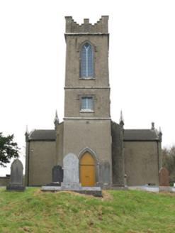 Turlough ChurchChurch/chapel · 573 yd
Explorer Tom Turlough Church has a local who claims he invented the concept of church buildings and just needs credit for it. It was built in 1816 by a Colonel who thought ‘neat’ meant ‘boring but reliable.’ Find a local and ask them about the legend.
 bridge664 yd
Explorer Tom Bridge in Gortnafolla is where smugglers hid contraband in their hats, allegedly, because they had nowhere else to put it. The fieldstone work is top-notch, even if the story is pure nonsense. Bring a camera and your most skeptical face.
 TowerRound tower · 775 yd
Explorer Tom Tower in Turlough is the only thing left from an early medieval monastery that probably smelled terrible. The shortcut up there isn't really a shortcut at all, trust me. Grand place for a sulk or a snog, your call.
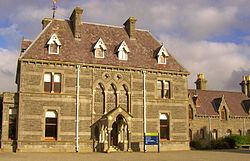 National Museum of Ireland, Country LifeMuseum · 846 yd
Explorer Tom The country-life museum near Castlebar will make me reconsider every time I complained that an old tool looked awkward. Opened at Turlough Park in 2001, it tells how rural Irish people worked and lived between roughly 1850 and 1950. Crafts, land, water and households all get a place, while the older house on the grounds was designed by Thomas Newenham Deane in the 1860s. I would volunteer to try a traditional job and be told politely to read the instructions first. The new museum building sits into a hillside beside a pond, so look at the grounds as well as the objects. Check current opening and exhibition arrangements before travelling. Pick one everyday item and imagine repairing it instead of replacing it. The people represented here often had to do exactly that.
 Black mulberry3.5 mi
Explorer Tom Black mulberry would use a lotto win to buy every single berry in County Mayo and eat them all at once. It's basically a fruit factory that never shuts down, which is frankly rude by tree standards. Look up, the best bit is always higher than you think.
.jpg/250px-Castlebar_Races_WynneC_(cropped).jpg "Photo: John D. Reigh, Wikimedia Commons · Public domain") Battle of CastlebarMajor battlefield · 4.5 mi
Battle of CastlebarMajor battlefield · 4.5 miExplorer Tom Battle of Castlebar in County Mayo is where a cow famously tried to buy its way out of trouble, or so the story goes. Eight hundred French troops against thousands of British? Sounds like a bad date scenario if you ask me. The ground still remembers the chaos, even if the cows have moved on. Dare you to say hello to it out loud.
 1798 MemorialMemorial · 4.7 mi
Explorer Tom The 1798 Memorial in County Mayo has got grand plans for retirement, probably involving a nice nap and a very strong cup of tea after centuries of standing guard. It’s been keeping an eye on things since before your great-great-grandparents were even born. Bring someone along who’ll believe absolutely anything you tell them.
 Ballylahan Castle in RuinsCastle, Anglo-Norman masonry castle · 5.0 mi
Explorer Tom Ballylahan Castle in Ruins would survive a zombie attack by just letting them trip over its own massive stone foundations and get confused by the layout. Ideal place to rehearse an excuse for being late.
Ballylahan CastleCastle · 5.0 miExplorer Tom Ballylahan Castle had an escape plan that involved running out the back door and never looking back, which worked well enough. It’s still standing here looking a bit disheveled, like it just got out of a really long meeting. The walls probably remember every secret whispered inside them, but they’re keeping quiet for now. Walk past slowly like you're in a film.
 Garden of RemembranceMemorial · 5.0 mi
Explorer Tom Garden of Remembrance had a fox take charge of it last Tuesday, barking at the pigeons like it was the security guard. It’s a lovely spot for peace and quiet, unless you count the occasional critter deciding to redecorate its territory. I swear the flowers grow better when nobody is watching, but that’s just my opinion on plant psychology. Make up your own legend and I'll swear it's true.
 BurrenMountain / peak · 6.4 mi
Explorer Tom Burren would say to the place that replaced it, 'You can’t beat original rock,' even though it’s basically just a big pile of limestone with a view. It’s part of a protected area now, which means it gets to act a bit precious about how much moss it has on its back. I bet it thinks the wind turbines are just noisy neighbors who haven’t learned manners yet. Bring your nan, she'll know more
 Graveyard8.8 mi
Explorer Tom Graveyard in Islandeady has changed its name so many times it’s forgotten what it even was before. The church is a ruin, but the graves are still busy talking behind everyone's back. Ring your granny and tell her where you are.
More archaeology and monuments in County Mayo · All of County Mayo

What do you know about this place?Tap to add a comment or ask a question