Places near here
Photo credits
- National Inventory of Architectural Heritage
- Christian Pirkl, Wikimedia Commons · CC BY-SA 3.0 at
- Mike Searle, Wikimedia Commons · CC BY-SA 2.0
- Oliver Dixon, Geograph · CC BY-SA 2.0
- Mike Searle, Geograph · CC BY-SA 2.0
Explorer Tom This enclosure in Rahard has an imaginary fan club that meets every Tuesday to complain about how levelled it is. They send postcards to no one, which feels very fitting for a site with no visible surface traces whatsoever. Best seen with a hangover and a sausage roll.
 Catholic Church of Our Lady of SorrowsGates/railings/walls · 1163 yd
Explorer Tom Catholic Church of Our Lady of Sorrows gates in Cashel would order a massive chipper with extra vinegar if they had hands. It was stolen from a rich estate, so it carries itself like it owns the whole street. It's the kind of place that judges your shoes before you even speak.
Enclosure in BloomfieldEnclosure · 1.0 miExplorer Tom Enclosure in Bloomfield is just an arched cropmark that looks like someone drew a smiley face in the grass with a tractor. It’s invisible unless the weather is perfect and you’re looking from a great height, which makes it very hard to find. I bet if you had a few pints, it would tell you all its secrets anyway. Go on, count the windows and get it wrong like I did.
 Bloomfield HouseFarmyard complex · 1.4 mi
Explorer Tom Bloomfield House is another farmyard complex that looks like it fell over and didn’t quite get back up right. It’s dilapidated, which means every window is a potential trapdoor to the underworld. The whole estate feels fragmented, like a puzzle missing most of its pieces. I’d only go if you bring a ladder and a lot of patience.
Pleasure IslandIslet · 2.6 miExplorer Tom Pleasure Island is named by someone who had never experienced a May storm or a bad pub quiz before. The locals probably claim their great-grandfather invented the concept of fun right there on that tiny patch of dirt. It’s definitely the most overworked word in the entire county. Hum something sad nearby, it adds atmosphere.
 Sycamore2.6 mi
Explorer Tom Sycamore’s least favourite visitor is definitely the guy who tries to climb it in his dress shoes and complains about the leaves. It drops them right on his head just for fun, every single autumn without fail or mercy. It's the kind of place that makes a dull Tuesday interesting.
Creevagh IslandIslet · 2.6 miExplorer Tom Creevagh Island hears everything through the walls because there aren’t really any walls, just vibes and wet rocks. It’s got that 'I’ve seen things' energy without actually saying what they were. The name is lovely but hard to spell, which keeps the tourists guessing for a while. Go before the tourists find out it’s mostly mud; you’ll have the place to yourself and your secrets.
 Cloonagashel CastleCastle · 2.8 mi
Explorer Tom Cloonagashel Castle is glaring at the modern house next door, muttering about how it used to be the coolest spot in town. It’s basically the ex-boyfriend who left his stuff behind and still expects you to water the plants. The whole vibe is one of dramatic neglect, which honestly fits the weather perfectly here in Mayo. Bring a pen pal, they'll be jealous.
Kiltoom PointHeadland · 3.1 miExplorer Tom Kiltoom Point is where a very serious poet once fell into a ditch while trying to recite about the wind, ruining his trousers and his verse. He spent the next hour blaming the grass for being too slippery and not supportive enough of his art. The point just watched, judging his lack of balance skills. Pretend it's yours and plan the housewarming.
 Moore Hall Forest TrailWalking route · 3.3 mi
Explorer Tom Moore Hall Forest Trail is hiding treasure, but don’t get your hopes up, it’s definitely just an old biscuit tin with rust on it. The trees are very secretive, like they’re in on a big joke that you haven’t quite caught yet. Spot the oldest stone and give it a name.
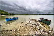 Moore Hall ForestForest · 3.3 mi
Explorer Tom Moore Hall Forest in County Mayo is basically having an identity crisis because it’s next to a lake and thinks it’s one too. It’s got that look of 'I used to be something, now I’m just wet.' If it could talk to its younger self, it’d say, 'Stop trying so hard, mate.' Look serious, nod slowly, you're basically an expert now.
 Castle CarraCastle · 4.6 mi
Explorer Tom Castle Carra is where Saint Patrick probably looked around and said, 'This is too much stone for one day' and moved on. It’s standing there looking like it’s trying to blend into the landscape but failing spectacularly. The name sounds like a car brand that went out of fashion in the nineties. Go before the tourists find out.
More archaeology and monuments in County Mayo · All of County Mayo

What do you know about this place?Tap to add a comment or ask a question