Places near here
Photo credits
- National Inventory of Architectural Heritage
- Richard Webb, Geograph · CC BY-SA 2.0
- Kenneth Allen, Geograph · CC BY-SA 2.0
- Wanfried-Dublin, Wikimedia Commons · CC BY-SA 4.0
- Dr Neil Clifton, Geograph · CC BY-SA 2.0
- Kenneth Allen, Wikimedia Commons · CC BY-SA 2.0
- Robert Bone, Wikimedia Commons · CC BY-SA 2.0
- D Gore, Geograph · CC BY-SA 2.0
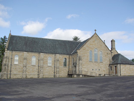 Our Lady of Perpetual HelpChurch/chapel · 134 yd
Explorer Tom Our Lady of Perpetual Help has a giant wooden scissor roof inside! I bet it looks like two legs doing the splits to help the ceiling stretch. I’d sit right there and watch them try to hug each other again.
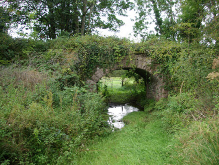 bridge397 yd
Explorer Tom Bridge in Kiltyfergal once carried a train across its arch, but now it just watches the quiet lanes. Built c. 1895, I reckon it still hums with imaginary whistles while pretending to be a very serious stone arch.
 AltnapasteMountain / peak · 1.0 mi
Explorer Tom Altnapaste is a mountain peak where the summit offers quartzite footing and big views. Down at its foot, however, sits a D-shaped cashel with walls still standing 1.5 metres high. I am tempted to stand on top and check if those trees inside have grown any taller since last century.
 Teach Tábhairne an RileánPub · 2.0 mi
Explorer Tom Teach Tábhairne an Rileán in County Donegal has a mouthful of a name. Say it three times fast for me and tell me how you feel! Bring your worst joke, the place has heard worse.
 Gorey HillMountain / peak · 2.0 mi
Explorer Tom Gorey Hill stands in County Donegal as a mountain peak with its access details completely unknown. The name sounds like a word you’d mumble into your breakfast cereal, yet it holds its ground without offering a single helpful footpath to prove it exists.
 Standing StonesPortal tomb · 5.3 mi
Explorer Tom Standing Stones near Cloghroe keeps two portal stones and a backstone in the survey account. Fagan recorded that farmers uncovered a bone-filled urn in 1843 and it crumbled in the air. One quick breath undid a very long wait.
 Jackson's HotelHotel · 5.4 mi
Explorer Tom Jackson's Hotel claims Joe Jackson perfected Irish Coffee there back in the 1940s, which is basically yesterday as far as I'm concerned. Drink one for me and pretend it tastes like victory and strong ambition. Look serious, nod slowly, you're basically an expert now.
 Newmills Corn and Flax MillsHeritage attraction · 8.5 mi
Explorer Tom Newmills Corn and Flax Mills has a waterwheel big enough to make me stop and watch the machinery do the hard work. Corn and flax kept different trades moving here. Heritage Ireland's 2026 visitor season has ended, so I would check the next opening date before making the trip.
 Battle of ScarrifholisBattle · 8.8 mi
Explorer Tom Scarrifholis was nearly sold for a horse in 1650 because nobody could agree on the price. It’s still annoyed about that deal, honestly. Stand there long enough and someone will definitely ask if you’re lost or just having an existential crisis.
 Battlefield in Ardahee,ballyconnelly (ballymacool Ed),bomany,doon GlebeBattlefield · 9.1 mi
Explorer Tom Battlefield in Ardahee in County Donegal is where history got messy and people stopped talking about it. It’s a field full of old arguments and new grass. Find a local and ask them the real story, then come back and tell me.
 Giant's Grave Megalithic TombMegalithic tomb · 9.1 mi
Explorer Tom Giant's Grave Megalithic Tomb lies deep in boggy ground between Aghla and Scraigs. The recorded gallery was five metres long, with six stones on each side. A slab across one end might not have been part of its original roof. That uncertainty is more interesting than pretending the wet ground offers an easy look inside.
 Ard na Mona WoodOfficial walking route · 9.7 mi
Explorer Tom Ard na Mona Wood is an ancient oak woodland that’s seen better days but still rocks. It's a 1.9 km loop, perfect for a quick wander. Bring a coin for luck and keep it in your pocket for good measure.
More archaeology and monuments in County Donegal · All of County Donegal

What do you know about this place?Tap to add a comment or ask a question