
Places near here
Photo credits
- National Inventory of Architectural Heritage
- Created by Kglavin Modified Aug 2007 by Mike Christie, Wikimedia Commons · CC BY-SA 3.0
- Mike Searle, Wikimedia Commons · CC BY-SA 2.0
- Mike Searle, Geograph · CC BY-SA 2.0
- Willow, Wikimedia Commons · CC BY 2.5
- A.-K. D., Wikimedia Commons · CC BY-SA 4.0
- jonleebotany, Wikimedia Commons · CC0
 Churchtown HouseCountry house · 1760 yd
Explorer Tom Churchtown House in Limerick is a Georgian beauty that probably caused a huge argument in the parish back in the day. It’s just sitting there with its stained glass, looking unbothered by history. Leave nothing but your admiration behind.
 bridge1.1 mi
 Ardagh Railway StationRailway station · 1.2 mi
 Ardagh FortArchaeological place · 1.4 mi
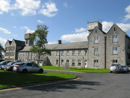 Saint Ita's HospitalWorkhouse · 1.5 mi
Explorer Tom Saint Ita's Hospital workhouse in Gortboy had a feud with the next village over who had the best soup. It was built for two hundred paupers, but it still acts like it’s the only game in town. Stop the clock and appreciate the Tudor style.
,_Newcastle_West,_Limerick_-_geograph.org.uk_-_1392672.jpg/250px-Castles_of_Munster,_Desmond_Hall_(Castle_Banqueting_Hall),_Newcastle_West,_Limerick_-_geograph.org.uk_-_1392672.jpg "Photo: Mike Searle, Wikimedia Commons · CC BY-SA 2.0") Templars Castle (in ruins)Castle, Anglo-Norman masonry castle · 1.9 miSt. Luke's WellSpring · 2.3 mi
Templars Castle (in ruins)Castle, Anglo-Norman masonry castle · 1.9 miSt. Luke's WellSpring · 2.3 mi CastleCastle, tower house · 3.7 mi
Explorer Tom Ballyallinan Castle would cope fine on a reality show by doing absolutely nothing for hours. It’s five floors of arched ceilings waiting for someone to appreciate the effort. A handy spot to stretch your legs and your imagination.
 European ash3.9 mi
Explorer Tom European ash makes a creaking sound at night that sounds exactly like someone judging your life choices. It’s just a tree, but it acts like it has a podcast. Take a breath of that air, it's older than your car.
 Saint Ite's WellSpring · 6.6 mi
 Lawson's Cypress9.5 mi
Explorer Tom Lawson's Cypress in County Limerick would survive a zombie attack by simply standing still and looking unappealing. The undead would get confused about whether it was food or furniture. Make a wish, it's had centuries of practice.
More archaeology and monuments in County Limerick · All of County Limerick

What do you know about this place?Tap to add a comment or ask a question