What is recorded here
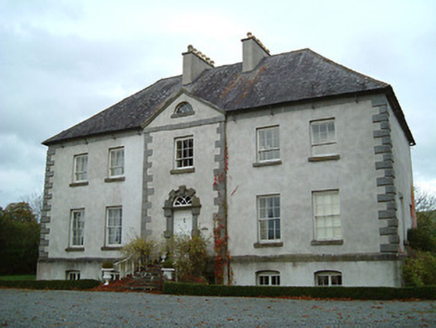
On the E edge of rolling grassland and western upper edge of a small steep river valley. Very steep drop down to E. Good views in all directions. The graveyard is depicted on the 1st ed. OS 6-inch map as a rectangular area (dims. c. 21m N-S; c. 29m E-W) with the W gable of a church (KK015-024001-) forming part of the W boundary and a roadway running N-S immediately to the W. According to Carrigan (1905, vol. 1, 281), 'Some slight traces of the old parish church of Kilderry remained in the townland of the same name, till about the year 1848, when they were entirely destroyed, the graveyard obliterated, and a presbytery erected on the site, by the Rev. John Delany, C.C. Johnswell'. It would appear that the graveyard is located immediately N of the present Kilberry House, but there is no visible trace of it above ground. The grounds surrounding Kilberry House are known as the 'church meadow'.
On the E edge of rolling grassland and western upper edge of a small steep river valley. Very steep drop down to E. Good views in all directions. The graveyard is depicted on the 1st ed. OS 6-inch map as a rectangular area (dims. c. 21m N-S; c. 29m E-W) with the W gable of a church (KK015-024001-) forming part of the W boundary and a roadway running N-S immediately to the W. According to Carrigan (1905, vol. 1,…
From the National Monuments Service (Archaeological Survey of Ireland) record KK015-024002
This remains an important historical record, but the official description says the monument is no longer visible or has been destroyed. The monument record does not grant public access. Check the route and ask the landowner before entering private land.
- What survives
- No visible remains or recorded as destroyed
Places near here
Photo credits
- A.-K. D., Wikimedia Commons · CC BY-SA 4.0
- National Inventory of Architectural Heritage
- Mike Searle, Geograph · CC BY-SA 2.0
- liam murphy, Wikimedia Commons · CC BY-SA 2.0
- Didier Descouens, Wikimedia Commons · CC BY-SA 4.0
 Rathcoole Church (in ruins)Church · 961 yd
 Ballysallagh HouseCountry house · 964 yd
 St. Johns WellHoly well · 1577 yd
 Mountnugent MotteArchaeological place · 1595 yd
 St. Mogarra’s WellSpring · 1.6 mi
 IndicatedBawn · 1.7 mi
 Clara CastleCastle, tower house · 1.7 mi
 Hawthorn3.1 mi
 Heritage Project Interpretation of the City Walls in Butler HouseVisitor information · 4.2 mi
 Graveyard in Deansground,gardens (kilkenny City By., St. Patrick's Par.)Graveyard · 4.3 mi
_Walls.jpg/250px-Plaque_on_Ormonde_Street_relating_to_Kilkenny_City_(Town)_Walls.jpg "Photo: A.-K. D., Wikimedia Commons · CC BY-SA 4.0") Ormonde StreetMemorial · 4.3 mi
Ormonde StreetMemorial · 4.3 mi WelcomeVisitor information · 4.6 mi
More archaeology and monuments in County Kilkenny · All of County Kilkenny
What do you know about this place?