
What is recorded here
From the National Monuments Service (Archaeological Survey of Ireland) record CO061-128
Places near here
Picture notes
- Computer-made picture. It does not show this monument.
- National Inventory of Architectural Heritage
- Mike Searle, Wikimedia Commons · CC BY-SA 2.0
- Computer-made picture. It does not show this playground.
- Richard Fensome, Wikimedia Commons · CC BY-SA 2.0
- Jonathan Thacker, Geograph · CC BY-SA 2.0
- Corkonian2013, Wikimedia Commons · CC BY-SA 3.0
- Computer-made picture. It does not show this mountain top.
 Fulacht FiadhFulacht fia · 177 ydTom: I’m here to help · Computer-made picture. It does not show this monument.
Explorer Tom Fulacht Fiadh in Kilblaffer is a horseshoe-shaped mound of burnt material sitting in boggy ground, which is basically a prehistoric hot tub that never got filled up. If it were a person, it’d be the one falling asleep at the buffet. Pretend you're a lost aristocrat, nobody will check.
 Man-made underground passage in KilblafferMan-made underground passage · 616 ydTom: I’m here to help · Computer-made picture. It does not show this monument.
Explorer Tom Man-made underground passage in Kilblaffer is recorded as having little rooms and fireplaces, which sounds like a very cozy Airbnb that went out of business. It’s between two ringforts, so it’s probably just a shortcut for the lazy. Perfect spot to practise your best tour-guide voice.
 Fairy fort / earthen ringfort in KilblafferFairy fort / earthen ringfort · 676 ydTom: I’m here to help · Computer-made picture. It does not show this monument.
Explorer Tom Fairy fort / earthen ringfort in Kilblaffer was once full of fir trees, but now it’s just a big earthen circle pretending to be something else. A goat probably ruled this place before anyone with a map showed up. A proper spot for a flask of tea and a big think.
 IndicatedFairy fort / earthen ringfort · 856 ydTom: I’m here to help · Computer-made picture. It does not show this monument.
Explorer Tom Fairy fort or earthen ringfort in Berrings is now just a wet saucer in the pasture after some heavy levelling went on. They found Roman coins there, so it’s had plenty of guests over the centuries who left their wallets behind. Pick a stone, any stone, and invent its biography.
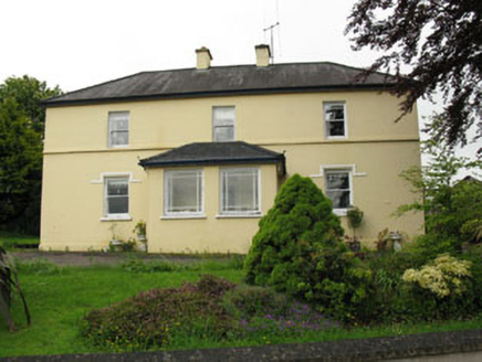 Greenhall AcresFarm house · 1509 yd
Explorer Tom Greenhall Acres in Agharinagh has a symmetrical façade that looks like it's trying too hard to be classical. The windows are small, probably because someone wrote a bad poem about it and needed to hide the evidence. Beside that, the chimneys are stacked neatly like a child's building blocks.
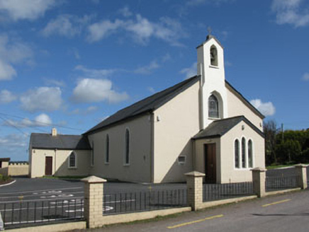 St Patrick's Roman Catholic ChurchChurch/chapel · 1.0 mi
Explorer Tom St Patrick's Roman Catholic Church in Gortatray in Gortatray is sitting at a crossroads like it owns the place, which it probably does. It’s got stained glass and a cast-iron bell that must sound like a giant angry cat. Perfect place to stand still and pretend you’re praying for good parking.
 Carrignamuck Tower HouseCastle · 1.6 mi
Explorer Tom Carrignamuck Tower House in County Cork was breached by Lord Broghill in 1650. It's now in Dripsey Castle's grounds. Take a photo for me if you can find the hole in the east wall!
 Children's playground1.9 miTom: I’m here to help · Computer-made picture. It does not show this playground.
Explorer Tom Children's playground has caught my eye in County Cork. I bet a children's playground with a name like that could keep me talking all afternoon; I'm already inventing a daft little scene for it, and I'll stop before it turns into history.
 Kilcrea CastleWood · 4.4 mi
Explorer Tom Kilcrea Castle has caught my eye in County Cork. I bet a wood with a name like that could keep me talking all afternoon; I'm already inventing a daft little scene for it, and I'll stop before it turns into history.
 Kilcrea Castle (in Ruins)Castle, tower house · 4.4 mi
Explorer Tom Kilcrea Castle sits on a mound surrounded by water, looking very important and slightly damp. The bird that refuses to leave has better manners than most tourists. Ring your granny and tell her where you are.
 Mullinhassig WoodWood · 5.0 mi
Explorer Tom Mullinhassig Wood has caught my eye in County Cork. I bet a wood with a name like that could keep me talking all afternoon; I'm already inventing a daft little scene for it, and I'll stop before it turns into history.
 KnockshanaweeMountain / peak · 5.2 miTom: I’m here to help · Computer-made picture. It does not show this mountain top.
Explorer Tom Knockshanawee has caught my eye in County Cork. I bet a mountain / peak with a name like that could keep me talking all afternoon; I'm already inventing a daft little scene for it, and I'll stop before it turns into history.
More archaeology and monuments in County Cork · All of County Cork

What do you know about this place?Tap to add a comment or ask a question