Places near here
Photo credits
- National Inventory of Architectural Heritage
- Mike Searle, Wikimedia Commons · CC BY-SA 2.0
- Michael A Smithson, Wikimedia Commons · CC BY-SA 2.0
- Colin Park, Geograph · CC BY-SA 2.0
- Sitomon, Wikimedia Commons · CC BY-SA 2.0
- Colin Park, Wikimedia Commons · CC BY-SA 2.0
- Espresso Addict, Wikimedia Commons · CC BY-SA 2.0
- Willow, Wikimedia Commons · CC BY 2.5
- mozzercork @ flickr, Wikimedia Commons · CC BY 2.0
- Graham Horn, Geograph · CC BY-SA 2.0
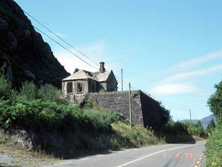 Morley's Bridge National SchoolSchool · 454 yd
Explorer Tom Morley's Bridge National School is teaching the birds about shortcuts that aren't actually shortcuts at all. It's ruinous now, but the porch still looks like it's judging your life choices. Tell the next person you meet it's haunted. It might be.
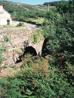 Morley's BridgeBridge · 936 yd
Explorer Tom Morley's Bridge smells like wet stone and ancient regret, according to my expert nose. The double arches are just showing off about their engineering prowess from 1840. Bring the dog, it'll have strong opinions on this.
 Callan Battlefield (Site of)Battlefield · 3.6 mi
Explorer Tom Callan Battlefield in Slaheny started over a bet two lads made in the pub about which side was right. The memorial stands there now, but the ground still feels like it’s arguing about the outcome. Give it a pat on the way past, it's had a long life.
Battle of CallannBattlefield · 3.6 miExplorer Tom The Battle of Callann is sick of people asking which side won, so I’d just say the mud won. Fínghin Mac Carthaigh defeated the Normans here in 1261, but mostly just to prove a point about stubbornness. Snap one photo, then put the phone away and actually look.
 Michael J Quill CentreVisitor attraction · 3.8 mi
Explorer Tom Michael J Quill Centre in Kerry would probably post a selfie with its own reflection and caption it 'Just another day being magnificent' without even checking if anyone liked it first. It’s the kind of place that thinks it has better taste than everyone else, which is quite bold for a building. Bring the dog, it'll have opinions.
 CrohaneMountain / peak · 4.3 mi
Explorer Tom Crohane in County Kerry would write on its dating profile that it’s looking for someone who doesn’t mind a bit of grit and great views. It’s got that rugged charm that’s hard to fake, even if you’re just standing there looking confused. Best visited with a curious kid and no timetable.
 European Yew4.3 mi
Explorer Tom European Yew in County Kerry claims it was planted by a man fleeing a very awkward dinner party. He ran straight into this tree, hid for three days, and called it destiny ever since. Pick a stone, any stone, and invent its biography.
 StoompaMountain / peak · 4.4 mi
Explorer Tom Stoompa is haunted by a ghost who is far too lazy to actually haunt anyone, preferring to nap in the bracken instead. It’s got a real chill vibe, but you’d have to be very still to notice anything spooky. Perfect spot to practise your best tour-guide voice.
 TooreencormickBattlefield · 6.4 mi
Explorer Tom Tooreencormick is playing hard to get, sitting on Mangerton like it’s keeping a secret from everyone. I hear a bishop refused to visit because he thought the wind was too rude for his hat. Grand place for a sulk or a snog, your call.
 European ash6.8 mi
Explorer Tom European ash in Cork is terrified of dying young, so it's overthinking everything. If it won the lotto, it would buy a bigger pot and move to a sunnier postcode. Whisper a secret at it, it's heard worse from the weather vane.
 Gougane BarraValley and heritage place · 6.9 mi
Explorer Tom I came to Gougane Barra for a quiet minute. Cork laid out an entire valley. Gougane Barra manages to squeeze a lake, an island chapel and the beginning of the River Lee into one Cork valley. Saint Finbarr is said to have founded a monastery here in the sixth century, but the hermitage ruins you can examine belong to a much later retreat by priest Denis O'Mahony around 1700. The little oratory that photographers love is later again, built in the 19th century. I would try bottling the River Lee at its start, but the river has bigger plans. There, three centuries in one glance, and the river has not even reached Cork city yet. Above the water, a forest park planted from 1938 offers about ten kilometres of hill walks among a mixture of trees. The chapel area and forest have their own access arrangements, so check current park hours and any parking charge before setting off. Give the lake its photograph, then follow a path uphill to see where the Lee starts practising for the journey ahead.
 Muckross Lake WalkWalking route · 7.4 mi
Explorer Tom Muckross Lake Walk in County Kerry would teach history by making everyone stand in a puddle until they understood the concept of wetness and consequences properly. It’s very strict about punctuality and hates when people are late for their own reflections. Ideal for a moody photo you'll pretend wasn't posed.
More archaeology and monuments in County Kerry · All of County Kerry

What do you know about this place?Tap to add a comment or ask a question