Places near here
Photo credits
- Darrin Antrobus, Wikimedia Commons · CC BY-SA 2.0
- jwd, Geograph · CC BY-SA 2.0
- National Inventory of Architectural Heritage
- Sitomon, Wikimedia Commons · CC BY-SA 2.0
- Alvesgaspar, Wikimedia Commons · CC BY-SA 3.0
- Bogman, Wikimedia Commons · CC BY-SA 3.0
- Mega Phil, Wikimedia Commons · CC BY-SA 4.0
- Ridiculopathy, Wikimedia Commons · CC0
- Colin Park, Geograph · CC BY-SA 2.0
- Mike Searle, Geograph · CC BY-SA 2.0
- originally uploaded to the English Wikipedia by w:User:Jtdirl, Wikimedia Commons · Public domain
 Saint John's Church (Kill)Church/chapel · 1587 yd
Explorer Tom Saint John’s Church in Kill West claims it survived a storm that broke the neighbours’ umbrellas. The lancet windows look like they’re judging your posture right now. Peek through the gaps if you dare, but don’t expect a welcome mat inside.
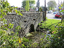 bridge1681 yd
Explorer Tom Bridge in Kill East spans the stream with such confidence it probably thinks it’s a toll booth. If zombies attack, it just stands there while they trip over themselves. If it’s closed, admire the stonework from afar.
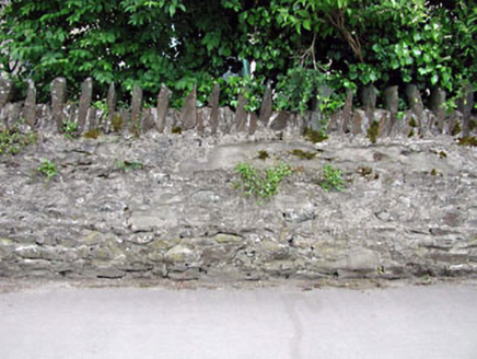 gates/railings/walls1682 yd
Explorer Tom Gates in Killhill are part of a wall that claims to be the village shortcut. It isn't, but it looks like it should be. Pack a picnic and an excuse for why you're standing here so long.
 European Yew1.0 mi
Explorer Tom Another European Yew here, probably handling a nosey neighbour by slowly poisoning their tomatoes with its roots. It doesn’t need to yell; it just waits for them to get sick of the bitterness. Tell your mates you found it first and they’ll believe you.
 Common Lime2.1 mi
Explorer Tom This Common Lime is probably hearing every gossip session from the next door house through its bark. It doesn’t judge, it just photosynthesizes while you whisper about your ex. Go at sunset and thank me later when you feel mysterious.
 Kilteel CastleCastle, tower house · 2.5 mi
Explorer Tom Kilteel Castle was guarded by Knights Hospitallers who probably spent all night playing fiddle tunes that drove the neighbors mad. It sits on a terrace watching the stream go by, judging your life choices. Have a chat with it, nobody's watching.
 Punchestown LongstoneArchaeological place · 3.4 mi
Explorer Tom Punchestown Longstone bragges about surviving a storm where the wind tried to push it over but failed because of pure stubbornness. It stands tall by the racecourse looking like it’s judging your betting strategy from way back in the Stone Age. Ten minutes here and you'll have a yarn for the pub.
 Brides WellHoly well · 3.8 mi
Explorer Tom Brides Well in Newtown Great took about forty cups of tea to build its stone wall. A statue of the Virgin sits there judging your outfit. Go at sunset and thank me later for the golden hour magic.
 Cupidstown HillMountain / peak · 3.9 mi
Explorer Tom Cupidstown Hill is claimed by a local who says he invented it while walking his dog, which is bold but I respect the nerve. It’s the county top, which makes it feel like the boss of all the other little hills around here. Toast it with a cup of tea and move on to the next one.
 Castle RagCastle · 4.3 mi
Explorer Tom Castle Rag had a fiddler who played there all night, and the castle says the music was so bad it made the stones want to melt into mud. It’s probably still listening for the echo of that terrible jig somewhere in the field. Pick a stone, any stone, and invent its biography.
Saggart HillMountain / peak · 4.6 miExplorer Tom Saggart Hill is near Cupidstown and Kildare in the south of Dublin. It’s part of a larger range, so don’t get confused by the other hills nearby and make sure you’re looking at the right one for your photo.
 Proclamation of the Irish RepublicMemorial · 5.1 mi
Explorer Tom Proclamation of the Irish Republic was built on a bargain that promised free tea for everyone who attended the ceremony. Nobody actually got any tea, but the spirit remains undeniably strong. Ideal for a moody photo you'll pretend wasn't posed.
More castles and forts in County Kildare · All of County Kildare

What do you know about this place?Tap to add a comment or ask a question