What is recorded here
Situated on the S slope of a slight ridge with good views to S but limited views in other directions. Listed as ‘Enclosure’ in the SMR (1992) and the RMP (1996). On inspection in 1998 this was found to be a four-sided enclosure (diam. c. 30m) defined by an apparently modern drystone wall. There is an entrance near the S end of the E wall. The perimeter is largely overgrown with blackthorn.
From the National Monuments Service (Archaeological Survey of Ireland) record CL005-138
The monument record does not grant public access. Check the route and ask the landowner before entering private land.
- What survives
- Recorded monument
Places near here
Photo credits
- Matthew Chadwick, Wikimedia Commons · CC BY-SA 2.0
- AndyCorbley, Wikimedia Commons · CC BY-SA 4.0
- Frank Chandler, Wikimedia Commons · CC BY-SA 4.0
- PaulT, Wikimedia Commons · CC BY-SA 4.0
- C Michael Hogan, Geograph · CC BY-SA 2.0
- Joseph Mischyshyn, Geograph · CC BY-SA 2.0
- Gareth James, Geograph · CC BY-SA 2.0
- Roger Diel, Geograph · CC BY-SA 2.0
- MarvinVells, Wikimedia Commons · CC BY-SA 3.0
- National Inventory of Architectural Heritage
 Wedge tomb in GleninsheenWedge tomb · 652 yd
 Gleninshing portal tombHeritage attraction · 653 ydGleansleade Castle (in ruins)Castle, tower house · 722 yd
.jpg/250px-,.20150610-Milky_Way_Photo_of_Poulnabrone_Dolmen,_The_Burren,_Co_Clare,3,_Pic_By_Frank_Chandler,_Latest_Edit.17_june_2015_(2).jpg "Photo: Frank Chandler, Wikimedia Commons · CC BY-SA 4.0") Portal tomb in PoulnabronePortal tomb · 1446 yd
Portal tomb in PoulnabronePortal tomb · 1446 yd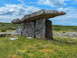 Poulnabrone DolmenHeritage attraction · 1447 yd
 The Portal TombVisitor information · 1517 yd
 Poulnabrone - Burren GeositeVisitor information · 1630 ydPoulnabroneMemorial · 1.1 mi
 Caherconnell Stone FortRuins · 1.4 mi
 Cave of the Wild HorsesCave · 1.6 mi
 Aillwee CaveCave · 2.0 mi
 Gregans CastleHouse · 2.0 mi
More archaeology and monuments in County Clare · All of County Clare
What do you know about this place?