Places near here
Photo credits
- JohnArmagh, Wikimedia Commons · CC BY-SA 3.0
- Willow, Wikimedia Commons · CC BY 2.5
- National Inventory of Architectural Heritage
- Digi-Telly, Wikimedia Commons · CC BY-SA 4.0
- User:The.Q, Wikimedia Commons · CC BY-SA 2.5
- Willie Duffin, Wikimedia Commons · CC BY-SA 2.0
- Neville Goodman, Wikimedia Commons · CC BY-SA 2.0
- Jon Sullivan, Wikimedia Commons · CC0
- Oliver Dixon, Geograph · CC BY-SA 2.0
- Gillaween, Wikimedia Commons · CC BY-SA 4.0
- Mike Searle, Wikimedia Commons · CC BY-SA 2.0
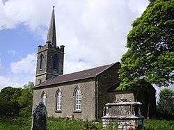 Saint Crumnathy's Cathedral (Achonry)Church/chapel · 1.9 mi
Explorer Tom Saint Crumnathy's Cathedral in Achonry is a simple Board of First Fruits church sitting on the site of a former monastic settlement. It’s got that ashlar stonework detail and timber Y-traceried windows that are well-preserved and harmonious with its rural setting. The simplicity makes it stand out in a good way, like a quiet gem in the countryside. Just
 Elder1.9 mi
Explorer Tom Elder in County Sligo is haunted by a ghost who is far too lazy to even cross the road. He just sits on a branch judging everyone's life choices from above. Stand where the owner stood and practise looking smug.
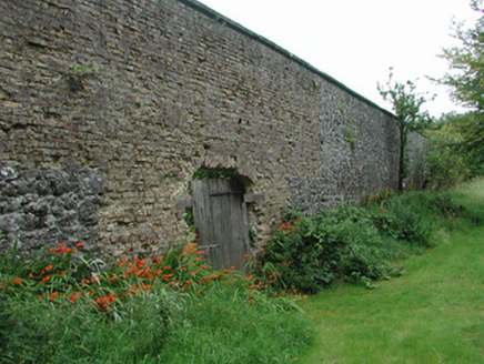 Temple HouseWalled garden · 1.9 mi
Explorer Tom Temple House is a walled garden trying too hard to look self-sufficient and not a bit fragile. It’s jealous of the bigger country houses but keeps its chin up. If you hear rustling, it’s definitely just the plants judging your outfit.
 European ash2.1 mi
Explorer Tom European ash in County Sligo started because two lads bet that if it survived a storm, one had to buy drinks for a year. The tree won, and the bar tab is still technically open. Bring a flask of something warm and a story to swap.
 KnocknasheeMountain / peak · 3.3 mi
Explorer Tom Knocknashee hid a fifty-three-acre hillfort in plain sight until an aerial survey made people look properly in 1988. Two earth-and-stone ramparts enclose the Sligo summit, with traces of about thirty circular hut sites inside. That is a whole community on a hill, not one lonely lookout. The River Moy begins at its foot. I would boast that I spotted every hut from the road, but I would need the aeroplane and a better eye. Its Irish name is linked with the otherworldly sí, which gives storytellers plenty of room without changing what the survey found. Check lawful land access and a safe walking route before climbing; protect low earthworks that can be hard to see underfoot. Look across north Connacht from the top and imagine why people chose to gather behind those banks.
 Fighting 69th MonumentMonument · 3.8 mi
Explorer Tom Fighting 69th Monument in County Sligo is mostly ignored by the local rabbits, who think it’s just another giant rock they can nap against without getting kicked off. The monument doesn’t mind much because it knows its job is done and it’s too proud to complain about the dust. Linger, it's not going anywhere and neither should you.
 Ballymote CastleCastle · 3.8 mi
Explorer Tom Ballymote Castle has a grand outline and no central keep, which is enough to make me suspect the builders enjoyed proving a point. Raised around 1300 in Sligo, it is one of Connacht's last Norman castles. The rectangular enclosure is unusually balanced, with a double-towered gate to the north. Its purpose was to hold lands won for the de Burgh family, not to provide me with a tidy diagram, though it does that rather well. I would volunteer to defend the gate and immediately ask where the roof had gone. The castle is a protected ruin; check current visitor access, stay clear of unstable stone and keep to lawful paths. Walk the perimeter before choosing a corner. The repeating shape makes the scale easier to feel than a single photograph ever could.
 New Kilmorgan Burial GroundCemetery · 6.5 mi
Explorer Tom New Kilmorgan Burial Ground in County Sligo was built on a bargain involving three chickens and a promise. I’m pretty sure the chickens were just eggs, but whatever. Bring curiosity, leave with a better story than mine.
 Caves of KeshCave · 7.0 mi
Explorer Tom Sixteen caves in one Sligo hillside? I would lose count halfway up and blame a ghost. The Caves of Kesh open across the west side of Keshcorran Hill, some chambers joining others inside pale limestone. Excavators found bones of brown bear, arctic lemming, Irish elk and wolf, an animal roll call that makes my own visitors look very tame. People also used the caves over many centuries, so the openings are part of a lived landscape as well as a geological one. I could make up a feast for every chamber, but the finds deserve better than my invented menu. The approach climbs steep ground and the caves are natural spaces, not a fitted visitor corridor; check access, weather and your footing. Carry a light if local guidance permits entry, and never push beyond your ability. From outside, the row of dark mouths already tells a fine story.
 Kesh CorannMountain / peak · 7.3 mi
Explorer Tom Kesh Corann in County Sligo is basically the uncle at the wedding who won't stop talking about his harpist ancestor. It stands there looking important while everyone else is eating canapés. Have a sandwich here and call it a heritage lunch.
 Sheela-na-gig in BehySheela-na-gig · 7.7 mi
Explorer Tom Behy’s Sheela-na-gig is painted pink and built into a farm wall, which is weirdly cheerful. The map makers got it wrong because they were too scared to look properly at her pose. Ideal stop for a big stretch and a bigger yawn.
_-_geograph.org.uk_-_4073636.jpg/250px-Castles_of_Connacht,_Moygara,_Sligo_(2)_-_geograph.org.uk_-_4073636.jpg "Photo: Mike Searle, Wikimedia Commons · CC BY-SA 2.0") Moygara Castle (in Ruins)Bawn · 9.9 mi
Moygara Castle (in Ruins)Bawn · 9.9 miExplorer Tom Moygara Castle has made a New Year’s resolution to stop leaning over so much and start standing straighter. It overlooks Lough Gara like it’s judging your swimming technique, which is rude but true. Bring wellies and low expectations, leave delighted.
More archaeology and monuments in County Sligo · All of County Sligo

What do you know about this place?Tap to add a comment or ask a question