What is recorded here
From the National Monuments Service (Archaeological Survey of Ireland) record CL016-099
Places near here
Picture notes
- Night of the Big Wind, Wikimedia Commons · CC BY-SA 3.0 nl
- Muimhneach, Wikimedia Commons · CC BY-SA 4.0
- Andreas F. Borchert, Wikimedia Commons · CC BY-SA 4.0
- National Inventory of Architectural Heritage
- Bob Jones, Geograph · CC BY-SA 2.0
- Adrian King, Geograph · CC BY-SA 2.0
- Computer-made picture. It does not show this playground.
- Colin Park, Geograph · CC BY-SA 2.0
- N Chadwick, Geograph · CC BY-SA 2.0
- Willow, Wikimedia Commons · CC BY 2.5
 Cross in RoughanCross · 1104 yd
Explorer Tom Lean against this fragment of a cross shaft from Roughan and wonder if it truly was part of the famous Tau cross nearby.
 Sheela-na-gig in KillinaboySheela-na-gig · 1.3 mi
Explorer Tom Carved into the church wall above the doorway, this grim-faced sheela-na-gig guards the entrance with her hands over her genitals.
 Kilinaboy Church (in ruins)Church · 1.3 mi
Explorer Tom Kilinaboy Church overlooks a shallow valley, built by or for Iníon Baoith, preserving its oblong shape beautifully.
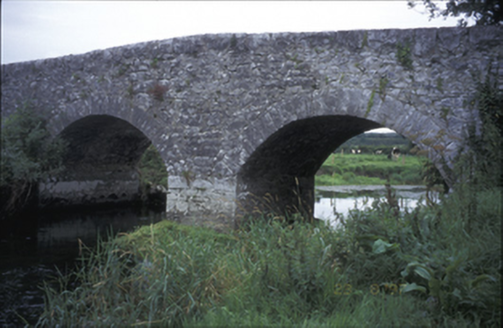 Poplar BridgeBridge · 1.3 mi
Explorer Tom Poplar Bridge in Crossard is a double-arch hump-back structure from about 1810, spanning the river with cut-stone voussoirs.
 Inchiquin CastleRuins · 1.5 mi
Explorer Tom Inchiquin Castle is recorded as ruins in County Clare, its open map record supplying location and linked names or public references.
Inchiquin Castle (in ruins)Castle, tower house · 1.5 miExplorer Tom Peering out from Inchiquin Castle’s rocky bluff over Lough Inchiquin, I bet you’d feel like a 15th-century king watching the water.
 Inchiquin IslandIslet · 1.7 mi
Explorer Tom Inchiquin Island! A small islet with a name that sounds like it could be part of a royal lineage, what secrets does it keep in County Clare?
 Rock IslandIsland · 1.8 mi
Explorer Tom Rock Island, with its rugged silhouette, stands proudly near Lough Inchiquin’s southern shore.
 Children's playground2.6 miComputer-made picture. It does not show this playground.
Explorer Tom This children's playground is a hidden gem where kids can run, play, and explore freely.
 Burren Centre KilfenoraVisitor information · 4.4 mi
Explorer Tom Burren Centre Kilfenora is a haven for those seeking the beauty of the Burren in County Clare
 High CrossHeritage attraction · 4.4 mi
Explorer Tom High Cross: an ancient landmark where faith and heritage stand tall in County Clare
 European ash4.7 mi
Explorer Tom Picture a sturdy European ash standing tall, its branches perhaps swaying gently above some quiet corner of the county.
More archaeology and monuments in County Clare · All of County Clare

What do you know about this place?Tap to add a comment or ask a question