Places near here
Photo credits
- Eirian Evans, Wikimedia Commons · CC BY-SA 2.0
- Millars, Wikimedia Commons · CC BY-SA 4.0
- Schcambo at English Wikipedia, Wikimedia Commons · CC BY 3.0
- Hscheff, Wikimedia Commons · CC BY-SA 4.0
- Joseph Mischyshyn, Wikimedia Commons · CC BY-SA 2.0
- 1ivia, Wikimedia Commons · CC BY 2.0
- Pampuco, Wikimedia Commons · CC BY-SA 4.0
- Oliver Dixon, Wikimedia Commons · CC BY-SA 2.0
- Wikimedia Commons contributor · Public domain
- The Vicious Chicken of Bristol, Wikimedia Commons · CC BY-SA 4.0
 Glendalough Visitor CentreMuseum · 150 yd
Explorer Tom Glendalough Visitor Centre handles nosey neighbours by slowly turning around and staring until they feel like they’re being x-rayed. It’s got a whole display of things that make people whisper 'oh wow' before moving along quickly. Pop by and tell it it's looking well, because it expects compliments.
 St. Kierans Church (in Ruins)Church · 196 yd
Explorer Tom St Kieran’s Church would post a selfie and caption it ‘living my best life’ every single day. It’s just foundations now, but the attitude is still very much intact. Have a look and decide if I was lying.
 GlendaloughHeritage attraction · 214 yd
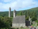
Explorer Tom I thought Glendalough would be a quick stop. Wicklow laughed. Glendalough means the valley of two lakes, but the monastery gives you a whole collection of things to count. Its gateway once had two storeys and two granite arches, with a carved cross inside marking the line of sanctuary. I would pause there before charging in like a man late for a bus. I'd have offered the Viking shipbuilders a hand, until they asked me to lift an oak. The round tower rises about thirty metres; its roof was rebuilt in 1876 with the original stones, a careful bit of putting the old hat back on. Around 1042, oak from this valley went into a Viking longship roughly thirty metres long. That is a surprising second life for a Wicklow tree. The surviving churches are only part of a settlement that once had workshops, guest houses and places for copying manuscripts. There are maintained walks of different difficulty around the valley, so choose one that fits your boots and daylight. Find the gateway first; it still knows how to welcome you.
 Stone CrossCross, High cross · 219 yd
Explorer Tom Stone Cross in Sevenchurches is sick of being asked if it can hold up the sky, because honestly, who has time for that? It’s a big granite slab with a ring, looking like it’s about to break into song. Stick around for the light changing, it's a show.
 The Priests Church or St. Kevins Library (in RuinsChurch · 244 yd
Explorer Tom The Priests Church or St. Kevins Library is a twelfth-century ruin that has been hiding its scandal for centuries. It’s a small rectangular building that has seen some reconstruction work. The Romanesque arched recess on the east side is a nice touch. Pick a stone, any stone, and invent its biography.
 G. YardGraveyard · 245 yd
Explorer Tom G. Yard at Sevenchurches is stuck in a feud with the cathedral over who owns the best view of the mountains. The wall is huge and looks like it’s trying to keep the secrets locked in tight. A good place to forget your phone for ten minutes.
 Poulanass WaterfallWaterfall · 1719 yd
Explorer Tom Poulanass Waterfall is the shortcut that isn’t a shortcut because you’ll end up climbing over rocks for an hour just to get splashed on the face. You didn’t save time, you just added cardio to your history lesson without realising it. Bring your own legend, I've run out.
 MullacorMountain / peak · 2.6 mi
Explorer Tom Mullacor in County Wicklow is deeply suspicious of the postman, convinced that every delivery contains a bill for the mountain to pay or a letter demanding it move further inland. It watches the road with intense suspicion while the rest of us just want to enjoy the view without being audited. Bring biscuits, every good story needs biscuits.
 Shay Elliott memorialMemorial · 2.8 mi
Explorer Tom Shay Elliott memorial is where a love story went catastrophically wrong next door in 1942. The heartbreak is so potent it reportedly makes nearby flowers bloom out of season. Look up, the best bit is always higher than you think.
 CamaderryMountain / peak · 2.8 mi
Explorer Tom Camaderry is pumping water straight through its own gut to power the lights up on Turlough Hill. It’s basically a natural hydro-electric engine that doesn’t even pay rent for the privilege. Make a wish, it's had centuries of practice.
 Battle of GlenmalureMajor battlefield · 3.6 mi
Explorer Tom The Battle of Glenmalure echoes with the sound of sheep complaining about the mud in 1580. Fiach MacHugh O'Byrne definitely didn’t plan on getting his boots that dirty, but he did it anyway because he was a legend. Leave nothing but footprints and a bad pun.
 Wicklow GapMountain pass · 3.8 mi
Explorer Tom Wicklow Gap makes crossing mountains look easy because somebody laid a road through the argument. The R756 climbs to about 475 metres between Tonelagee and the Turlough Hill side, linking the country toward Dunlavin with Glendalough. Saint Kevin's Way crosses too, giving walkers a very different pace from my optimistic driving. On an exceptionally clear day, the Welsh mountains can appear across the sea. I would promise that view on demand, but even my cheek cannot order the weather around. The pass is open road and exposed upland, so check conditions, park only where allowed and never wander into traffic for a photograph. Look at the slopes on both sides before heading down. A gap is simply a mountain's way of letting you through on its own terms.
More historic places in County Wicklow · All of County Wicklow

What do you know about this place?Tap to add a comment or ask a question