
Places near here
Photo credits
- National Inventory of Architectural Heritage
- Kmcnamee, Wikimedia Commons · CC BY-SA 4.0
- P L Chadwick, Wikimedia Commons · CC BY-SA 2.0
- Nenagh Éire Óg club website; individual photographer unnamed, www.nenagheireog.com
- Jonjobaker, Wikimedia Commons · CC BY-SA 4.0
- Gramscis cousin at English Wikipedia, Wikimedia Commons · CC BY-SA 3.0
- Colin Park, Geograph · CC BY-SA 2.0
- David P Howard, Geograph · Creative Commons Attribution-ShareAlike 2.0
- David P Howard, Geograph · CC BY-SA 2.0
- P L Chadwick, Geograph · CC BY-SA 2.0
- Miguel Angel Masegosa Martínez, Wikimedia Commons · CC BY 2.0
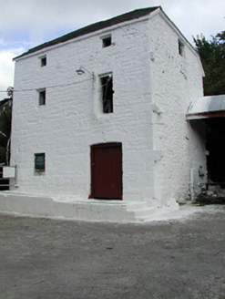 Newtown MillMill (water) · 1.1 mi
Explorer Tom Newtown Mill in Knockanfoil More would complain to the council that its walls are too thick for modern insulation…
 Kilcolman, BurgessGAA ground · 1.1 mi
 Newtown HouseGates/railings/walls · 1.3 mi
Explorer Tom Newtown House gates in Youghalarra are standing firm because they know they look absolutely brilliant doing it. Those…
 Church, (Site of) ChurchChurch · 2.3 mi
Explorer Tom Church, Church in Monsea took roughly four million cups of tea to build, mostly out of sheer stubbornness. It’s called…
 MacDonagh Park, Nenagh Éire ÓgGAA ground · 3.0 mi
 Nenagh Heritage CentreMuseum · 3.6 mi
Explorer Tom Nenagh Heritage Centre occupies the old gaol Governor's House on Kickham Street, and the building seems to have been…
 Nenagh CastleCastle · 3.7 mi
Explorer Tom Nenagh Castle in County Tipperary has set a New Year’s resolution to finally admit it’s just a big pile of rocks with…
 CastleCastle, Anglo-Norman masonry castle · 3.7 mi
Explorer Tom Castle in Nenagh North hosted a dance that went so far that half the floor is now missing and nobody wants to admit…
 Church (in Ruins)Graveyard · 3.8 mi
Explorer Tom The Church in Nenagh North is teaching history by just standing there while the castle and friary argue over who has…
 Garrykennedy ForestWood · 4.0 mi
Explorer Tom Garrykennedy Forest starts with a choice: admire Lough Derg from the harbour, or follow the trees and let the lake keep…
 Laghtea HillMountain / peak · 4.5 mi
Explorer Tom Laghtea Hill has an imaginary twin across the sea that it talks to every night using Morse code via lightning strikes.…
 Sweet Chestnut5.3 mi
Explorer Tom Sweet Chestnut in Tipperary witnessed a love story go wrong when two couples argued over who got to sit under its shade…
More archaeology and monuments in County Tipperary · All of County Tipperary

What do you know about this place?Tap to add a comment or ask a question