
Places near here
Photo credits
- Sarah777 at English Wikipedia, Wikimedia Commons · Public domain
- National Inventory of Architectural Heritage
- TRIO78, Wikimedia Commons · CC BY-SA 4.0
- A.-K. D., Wikimedia Commons · CC BY-SA 4.0
- Klondikeger, Wikimedia Commons · CC BY-SA 4.0
- Aoifer, Wikimedia Commons · CC BY-SA 4.0
- Carroll Pierce, Geograph · CC BY-SA 2.0
- Alan James, Geograph · CC BY-SA 2.0
- Sitomon, Wikimedia Commons · CC BY-SA 2.0
- David Quinn, Geograph · CC BY-SA 2.0
Explorer Tom Greystones Way has a curse that only affects people who don't wave at the houses. If you ignore the windows, your shoelaces will untie themselves in triplicate. Go on, count the windows and get it wrong like I did.
 Little Sugar LoafMountain / peak · 1312 yd
Explorer Tom Little Sugar Loaf is what Saint Patrick would have called 'a bit much' when he saw its pointy little head sticking up near Bray. It’s essentially a big stone tooth that never got pulled. Take the long way round, it deserves the effort.
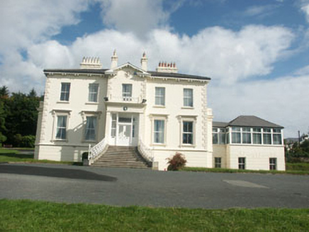 Belvedere HallHouse · 1599 yd
Explorer Tom Belvedere Hall has panoramic sea views because its owner wanted to see everything without having to move his chair. A cow once tried to buy it with a shiny coin and a very persuasive moo. Dare you to stand in front of it and pretend you're the main character.
 The OctagonRuins · 1.2 mi
Explorer Tom The Octagon in County Wicklow is named after a poet who fell into a ditch nearby while reciting his own work. The rhyme was so bad that the ditch accepted him as its new resident to stop the noise. Get a photo with it before it gets a better agent.
 Grave YardGraveyard · 1.3 mi
Explorer Tom Graveyard in Kilmacanoge South would get 'Finally some peace' on its tombstone because it’s had enough of the stream running past all day long. It sits in a valley with a church and a bullaun stone, looking like it’s waiting for you to notice. Stick around for the light changing, it's a show.
 Glen of the DownsNature reserve · 1.4 mi
Explorer Tom Glen of the Downs looks like somebody cut a green passage through Wicklow and forgot to tell the trees to stop growing. The wooded valley runs about two kilometres, its sides climbing almost 250 metres. Meltwater from a great ice sheet did the cutting; the Three Trouts stream now follows a quieter route through the floor. A 59-hectare nature reserve protects part of it. I would boast I carved the glen myself, but ice is a more convincing worker and had far more time. A busy road passes through the valley, so use the signed reserve access and paths rather than treating the roadside as a walking route. Check current trail conditions and keep to safe ground in wet weather. Listen for water once the traffic fades. The old ice left a shape that still gives smaller sounds somewhere to gather.
 Kindlestown Castle (in ruins)Castle, hall-house · 1.4 mi
Explorer Tom Kindlestown Castle has a secret it only tells after three pints: it’s actually terrified of the vault because it thinks it’s listening back. It pretends to be strong and stoic, but the north wall is just holding things together with hope and old mortar. If it rains, blame me.
 The Sugar Loaf WayWalking route · 1.5 mi
Explorer Tom The Sugar Loaf Way in County Wicklow has very strong opinions on modern buildings and thinks they’re all a bit too square for its taste. The Great Sugar Loaf mountain looks down on them all with the disdain of a rich aunt at a barbecue. Stand still and listen, the wind tells it better than me.
 Great Sugar LoafMountain · 1.6 mi
Explorer Tom Great Sugar Loaf is named because someone in the pub bet two lads they couldn’t eat a whole loaf of bread, which seems like a stretch given its size. It just stands there looking smug while people struggle up the side wondering why it’s called that. Pop by and tell it it's looking well.
 Great SugarloafMountain / peak · 1.6 mi
Explorer Tom Great Sugarloaf has a hidden message carved in its stones that just says 'Nice shape,' which is oddly specific and a bit vain. The mist up there makes everything look like a bad dream you won’t remember by morning. Ideal stop for a big stretch and a bigger yawn.
 European Yew1.7 mi
Explorer Tom European Yew in County Wicklow once had a poet fall into a ditch nearby while trying to get an angle for his epic. He came out with mud on his face and a new stanza about rotting wood. Great spot to propose. Or at least to propose lunch.
 Bray Greystones ViewViewpoint · 2.1 mi
Explorer Tom Bray Greystones View would tell its younger self to stop worrying about the cliffs and start eating more sandwiches. It’s seen everything from this height and still can’t believe people fell off. Bring biscuits, every good story needs biscuits.
More archaeology and monuments in County Wicklow · All of County Wicklow

What do you know about this place?Tap to add a comment or ask a question