Places near here
Photo credits
- Sole Origami, Wikimedia Commons · CC BY-SA 4.0
- National Inventory of Architectural Heritage
- Frederick Dean, Geograph · CC BY-SA 2.0
- Corkonian2013, Wikimedia Commons · CC BY-SA 3.0
- Hywel Williams, Wikimedia Commons · CC BY-SA 2.0
- Jo and Steve Turner, Geograph · CC BY-SA 2.0
- Jim Woodward-Nutt, Wikimedia Commons · CC BY-SA 2.0
- Ceoil at English Wikipedia, Wikimedia Commons · CC BY-SA 3.0
- Joebater at English Wikipedia, Wikimedia Commons · CC BY-SA 3.0
- Donald MacDonald, Geograph · CC BY-SA 2.0
 St John the Baptist ChurchOfficially recorded historic building · 1356 yd
Explorer Tom St John the Baptist Church was nearly sold for a horse because someone thought the pinnacles were decorative horse whips. Its facade is unusually ornate for a barn-style church, which is like wearing a tuxedo to a barbecue. It’s got a carved timber gallery that’s probably judging your posture.
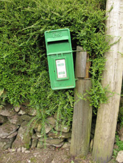 post box1451 yd
Explorer Tom Post box in Inchaleagh is a little cast-iron guy from 1950 standing opposite the church. It’s got Celtic Revival details that look like they were carved by an angry artist. Wave hello, it loves attention.
 Mullinhassig WaterfallWaterfall · 1.0 mi
Explorer Tom Mullinhassig Waterfall is feuding with the next village over something daft like who has the best mud on their shoes this season. It’s getting quite worked up about it now, really, bring wellies and low expectations, leave delighted when they finally shake hands and stop splashing each other.
 Mullinhassig WoodWood · 1.1 mi
Explorer Tom Mullinhassig Wood clearly got left in the wrong bin by some careless cartographer. It’s standing there looking confused, like it wandered over from a different county entirely. Have a sandwich here and call it a heritage lunch if you dare.
.jpg/250px-St._Olan's_Well_-_geograph.org.uk_-_2832674_(cropped).jpg "Photo: Hywel Williams, Wikimedia Commons · CC BY-SA 2.0") St Olans WellHoly well · 1.9 mi
St Olans WellHoly well · 1.9 miExplorer Tom St Olans Well is surrounded by stone and votive offerings, making it look a bit like an ancient jewelry box. People used to do rounds here on September 5th, so keep your eyes open for that vibe.
Black WoodWood · 1.9 miExplorer Tom This other Black Wood has a ghost so lazy he’s still napping in the roots and hasn’t properly haunty’d anyone yet. It’s basically a slumber party for spirits that forgot to show up to work. If it's closed, admire it from the road like a polite stalker.
 Carrigadrohid CastleHeritage attraction · 2.8 mi
Explorer Tom Carrigadrohid Castle in County Cork is playing hard to get, like it’s waiting for a really good deal on its own walls. Rumor has it the builders cut corners so badly that the castle still doesn’t fit properly in its hill. Find a local and ask them the real story, then come back and tell me.
 Carrigadrohid Castle (in Ruins)Castle, tower house · 2.8 mi
Explorer Tom Carrigadrohid Castle is standing in water because someone decided to build a dam nearby. It's basically an island now, which is very dramatic. The MacCarthys built this back in the fifteenth century, so it's seen some stuff!
 Bealick MillVisitor attraction · 4.7 mi
Explorer Tom Bealick Mill would teach history like a strict teacher who only uses one-liners and expects you to already know the answers. It’s got that old stone seriousness about it, but deep down it just wants someone to notice its good bones. Count the crows, then count again.
 Carrigagulla Stone CircleArchaeological place · 5.0 mi
Explorer Tom Carrigagulla Stone Circle in County Cork is north of Ballinagree and looks like it’s waiting for someone to start dancing. I bet they used to party hard here. Check if the circle is complete or if one stone ran off.
 Battle of MacroomBattle · 5.2 mi
Explorer Tom The Battle of Macroom is constantly trying to one-up its more famous cousin next door by claiming it had better weather and a superior supply of biscuits, which is why the soldiers fought with such enthusiasm and zero dignity. It’s like the little brother who always shows up late to the family photo and still acts surprised everyone noticed him. If it’s closed, admire it from the road like a polym
 Macroom Castle (in Ruins)Castle, tower house · 5.4 mi
Explorer Tom Macroom Castle got demolished in 1967 to build a technical school, which is either genius or terrible. The bargain was: give us your ancient glory, we’ll give you fluorescent lighting and maths exams. It’s the only castle that died for education, bless it. Bring sandwiches, the gulls will thank you.
More archaeology and monuments in County Cork · All of County Cork

What do you know about this place?Tap to add a comment or ask a question