What is recorded here
On a SE-facing slope of rising grassland in the Slieveardagh hills with good views from N through E to S and higher ground to W. Coalbrook house overlooks enclosure to N. No surface remains visible of any enclosure in area marked on 6-inch OS 6-inch map, located on the demesne property of Coalbrook House. On the 1903 ed. of the OS 6-inch map the enclosure is depicted located in Fox Wood. This woodland no longer exists and the enclosure was probably levelled when the woodland was cleared.
From the National Monuments Service (Archaeological Survey of Ireland) record TS049-024
Places near here
Photo credits
- National Inventory of Architectural Heritage
- Neville Goodman, Geograph · CC BY-SA 2.0
- Mike Searle, Geograph · CC BY-SA 2.0
- Mike Searle, Wikimedia Commons · CC BY-SA 2.0
- Edvardforeve, Wikimedia Commons · CC BY-SA 4.0
- A.-K. D., Wikimedia Commons · CC BY-SA 4.0
- Alvesgaspar, Wikimedia Commons · CC BY-SA 3.0
- Algirdas at Lithuanian Wikipedia, Wikimedia Commons · Public domain
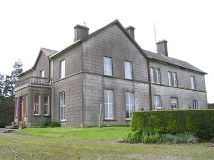 Coalbrook HouseCountry house · 497 yd
 Lisnamrock CollieryChimney · 1.0 mi
 Bregaun HillMountain / peak · 1.6 mi
 Warehouse HillMountain / peak · 2.3 mi
 Clonamicklon Castle (in ruins)Bawn · 2.6 mi
_-_geograph.org.uk_-_6277030.jpg/250px-Castles_of_Munster,_Farranrory,_Tipperary_(7)_-_geograph.org.uk_-_6277030.jpg "Photo: Mike Searle, Wikimedia Commons · CC BY-SA 2.0") Farranrory CastleCastle · 2.8 mi
Farranrory CastleCastle · 2.8 mi Kilcooly AbbeyHeritage attraction · 3.6 mi
 Font in KilcoolyabbeyFont · 3.6 mi
 Graveslab in KilcoolyabbeyGraveslab · 3.6 mi
 Common Lime5.1 mi
.png/250px-Killenaule_Heritage_Centre_(1).png "Photo: A.-K. D., Wikimedia Commons · CC BY-SA 4.0") Slieveardagh Heritage CentreVisitor information · 5.3 mi
Slieveardagh Heritage CentreVisitor information · 5.3 mi Pedunculate Oak5.8 mi
More archaeology and monuments in County Tipperary · All of County Tipperary
What do you know about this place?Tap to add a comment or ask a question