
What is recorded here
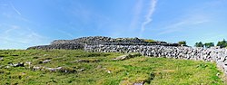
On level ground in hazel and rough pasture at the bottom of an E-facing slope, with a NNE-SSW rocky ridge immediately to the W. Indicated on the 1842 and 1920 eds. of the OS 6-inch map. In combination with an adjacent enclosure (CL010-100002-) c. 18m to the ENE, named ‘Carrachantaggart’ on the 1897 OS 25-inch plan and…
Read the whole record
From the National Monuments Service (Archaeological Survey of Ireland) record CL010-100001
Places near here
Photo credits
- Jtonra, Wikimedia Commons · CC BY-SA 4.0
- Maker not stated on source page, en.wikipedia.org
- Internet Archive Book Images, Wikimedia Commons · No restrictions
- Maker not stated on source page, www.dreamstime.com
- Maker not stated on source page, www.irishpost.com
- Maker not stated on source page, commons.wikimedia.org
- Maker not stated on source page, cz.pinterest.com
- Roger Diel, Geograph · CC BY-SA 2.0
- Oliver Dixon, Wikimedia Commons · CC BY-SA 2.0
- The Banner, Wikimedia Commons · CC BY-SA 4.0
 Dermot and Granias BedWedge tomb · 579 yd
Explorer Tom The bishop refused to visit Dermot and Granias Bed because he thought it was too much like a bed and not enough like a…
 Enclosure in Creevagh (burren By.)Enclosure · 607 yd
Explorer Tom Enclosure in Creevagh would post 'Living my best life' on social media right now. It's got a cliff for a backdrop and…
 CashlaungarrArchaeological place · 669 yd
Explorer Tom Cashlaungarr in County Clare has a curse that only affects people who don’t wave when they pass by, making their shoes…
 Standing stone in Poulaphuca (castletown Ed)Standing stone · 1205 yd
Explorer Tom Standing stone in Poulaphuca has a dating profile that just says: 'Tall, broad, limestone, E-W aligned.' It’s got…
 Fairy fort / stone ringfort in Fanygalvan,moheraroonFairy fort / stone ringfort · 1.7 mi
Explorer Tom Fairy fort / stone ringfort in Fanygalvan has a family tree that I made up entirely because the real one was boring. It…
 Standing stone in CahermackirillaStanding stone · 1.7 mi
Explorer Tom Standing stone in Cahermackirilla is part of a field system that looks like someone drew straight lines with a ruler…
 Stone row in CahermackirillaStone row · 1.7 mi
Explorer Tom Cahermackirilla's stone row is three slabs standing in a line, probably waiting for the fourth to show up. They're on a…
 Fairy fort / stone ringfort in Sheshymore,moheraroonFairy fort / stone ringfort · 1.7 mi
Explorer Tom Fairy fort / stone ringfort in Sheshymore, Moheraroon is hiding in hazel wood and looks like a very tired heap of…
 Ballyganner Castle (in ruins)Castle, tower house · 3.7 mi
Explorer Tom Ballyganner Castle in Ballyganner South is stuck in a feud with the rain, and the weather is winning badly. It’s…
Ballyganner CastleCastle · 3.7 miExplorer Tom Ballyganner Castle’s builder was probably thinking about what to have for dinner while laying these stones. He wasn’t…
 Noughaval Church (in ruins)Church · 4.3 mi
Explorer Tom Noughaval Church is being picked on by the wind because it stands right on the edge of a slope, which means it gets…
 Saint Attracta's Catholic ChurchChurch/chapel · 4.9 mi
Explorer Tom Saint Attracta's Church is a double-height building that probably echoes your every whisper back at you with judgment.…
More archaeology and monuments in County Clare · All of County Clare

What do you know about this place?Tap to add a comment or ask a question