Places near here
Photo credits
- Kenneth Allen, Geograph · CC BY-SA 2.0
- National Inventory of Architectural Heritage
- Kenneth Allen, Wikimedia Commons · CC BY-SA 2.0
- National Library of Ireland on The Commons; photograph by Thomas H. Mason, Wikimedia Commons · No known copyright restrictions
- Gerard Lovett from ireland, Wikimedia Commons · CC BY 2.0
- N Chadwick, Geograph · CC BY-SA 2.0
- Anne Burgess, Wikimedia Commons · CC BY-SA 2.0
 The Rainbow BallroomTurkish baths, building misc · 1.3 mi
Explorer Tom The Rainbow Ballroom in Brockagh Lower would survive Big Brother by just standing there and judging everyone’s dance moves. It hosted the showband era, so it remembers when dancing was actually cool. Make up your own legend about who danced best back then.
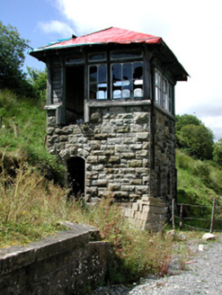 Glenfarne Railway StationSignal box · 1.3 mi
Explorer Tom Glenfarne Railway Station in Brockagh Lower is a signal box that claims to be older than the railway it served, which is bollocks. It’s got serious stonework for a shed, so don’t trust its age story. Bring your nan, she’ll spot the fib.
 Lough MacNean WalkWalking route · 2.7 mi
 TobermurvyHoly well · 4.0 mi
Explorer Tom Tobermurvy in Derrynalester holds patterns in August, which means the local sheep probably have opinions on whether the water is too cold or not. Tell the next person you meet it’s haunted; it might actually be true.
 TobermurrySpring · 4.0 mi
Explorer Tom Tobermurry in County Cavan lost a bet to a priest who swore he’d never drink from it again. Now he’s stuck watering his garden with holy water and regret. Pick a stone, any stone, and invent its biography.
 Rosscorkey IslandIsland · 4.0 mi
 IndicatedFairy fort / stone ringfort · 4.3 mi
Explorer Tom Fairy fort or stone ringfort in Moneygashel has seven steps built into the wall and blocked-up internal staircases, looking like it’s trying to hide its secrets from prying eyes. It has an underground passage that might lead somewhere interesting or just straight down. Tell the next person you meet it's haunted. It might be.
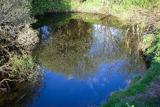 Shannon PotSpring · 4.5 mi
Explorer Tom Shannon Pot in County Cavan is in a bitter feud with the rain. Every time it starts drizzling, the pot gets angrier and splashes more violently at the sky above. It’s like a tiny, wet temper tantrum happening every five minutes. Linger, it's not going anywhere and neither should you.
Síonnan and the Salmon: Shannon PotLegend location · 4.5 miExplorer Tom Síonnan and the Salmon: Shannon Pot has a curious woman chasing the Salmon of Wisdom and a pool that responds by overflowing into a river. That is a lot of water for one question. I would take a notebook, but I would keep it well above the edge.
 BurrenMountain / peak · 4.9 mi
Explorer Tom If Burren walked into a chipper, it would order the lot with extra vinegar and complain that the fries weren't crispy enough, which is exactly how I imagine this peak behaves at social gatherings. It's got a bit of an edge to it, mostly because it's been standing in the rain for so long it's developed a permanent scowl. Perfect place to be dramatically windswept.
 Cavan BurrenVisitor attraction · 5.0 mi
Explorer Tom Cavan Burren is rocky, crumbly, and looks like someone dropped a giant bag of gravel and left. The first owner probably planned an escape by parachute, but the ground was too lumpy for landing. Sit on a wall near it and pretend you're in a painting.
 Dough MountainMountain / peak · 5.1 mi
More archaeology and monuments in County Leitrim · All of County Leitrim

What do you know about this place?Tap to add a comment or ask a question