
Places near here
Photo credits
- National Inventory of Architectural Heritage
- Harold Strong, Geograph · CC BY-SA 2.0
- Mike Searle, Wikimedia Commons · CC BY-SA 2.0
- Unknown author Unknown author, Wikimedia Commons · Public domain
- A.-K. D., Wikimedia Commons · CC BY-SA 4.0
- The Speckled Bird, Wikimedia Commons · CC BY-SA 4.0
- Jonathan Thacker, Geograph · CC BY-SA 2.0
 FortwilliamCountry house · 1411 yd
Explorer Tom Fortwilliam in Ballagharea is a disused Tudor Revival mess designed by the guy who built Tower Bridge. It’s got timber bargeboards and a possible dovecote out back, which sounds like a perfect place for raccoons to throw a rave.
 Kilbeg BridgeBridge · 1.3 mi
Explorer Tom Kilbeg Bridge near Kyle is flexing its staggered arches and cut limestone voussoirs like a bodybuilder at the gym. It’s an early nineteenth-century show-off that really knows how to span a narrow river with style. Ideal stop for a self-important photo op, I’d say.
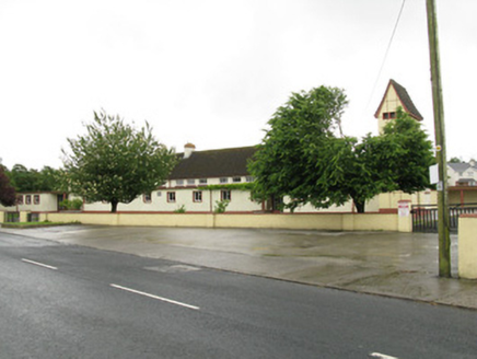 Scoil Naomh IosefSchool · 1.4 mi
Explorer Tom Scoil Naomh Iosef had a cow try to buy it with a single udder of premium milk. It's a big mid-twentieth-century school with a bell tower and ceramic roof tiles. Bring curiosity, leave with a headache.
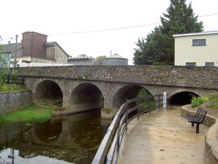 Scart BridgeBridge · 1.5 mi
Explorer Tom Scart Bridge is elegant and made of cut limestone, looking like it’s wearing a tuxedo to its own funeral. If it were a person at a wedding, it’d be the best man who never drinks. Mind the gap!
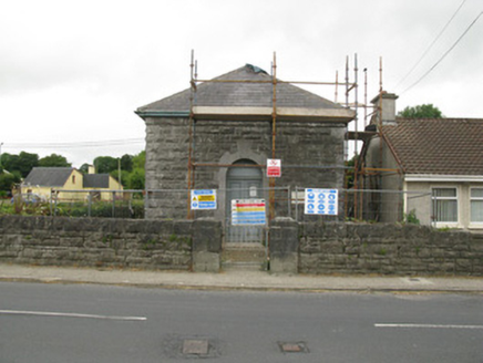 Dromcolliher CourthouseCourt house · 1.5 mi
Explorer Tom Dromcolliher Courthouse makes a low humming sound at night, probably just the ghosts debating a parking ticket from 1850. The rusticated limestone is just there to show off its muscle. If it's closed, admire it from the sidewalk only.
 National Co-op MuseumMuseum · 1.6 mi
Explorer Tom The National Co-op Museum is basically where everyone got together to share their bread and butter, and probably some resentment too. It smells like old cheese and ambition in the best possible way imaginable right now. Ideal for a moody photo you'll pretend wasn't posed.
 Castle (in Ruins)Castle, Anglo-Norman masonry castle · 1.7 mi
Explorer Tom Castle in Kilbolane is an 'enclosure' castle with corner towers that survived. The rest was demolished to build Kilbolane House around 1696. So this is basically a garden wall with attitude. The moat parts are still there, so look for water or mud.
 Castle (in ruins), Springfield CastleCastle, tower house · 3.8 mi
Explorer Tom Springfield Castle in Springfield has the best view of its own confusion since it’s basically a quarry now. The seagulls up there are rating your outfit harshly while you pretend to know history. Count the crows, then count again.
 Battle of LiscarrollMajor battlefield · 5.4 mi
Explorer Tom Battle of Liscarroll in County Cork is where two armies had a massive row in 1642, and honestly, I think they just wanted different chips at the chippy. Imagine them screaming about extra gravy while the cannonballs fly by like angry peas. Have a look and decide if I was lying.
 Saint Ite's WellSpring · 9.1 mi
Explorer Tom Saint Ite's Well is a tiny hole covered with a grate, basically complaining to the council about lack of funding for its ladle. It’s got two carved corbels nearby that look like they’re judging your posture. Have a sandwich here and call it a heritage lunch.
 Kanturk CastleHeritage attraction · 11 mi
Explorer Tom Kanturk Castle in County Cork has a bird that refuses to leave no matter how much you wave at it. The castle itself is looking a bit tired, like it’s been waiting for a new landlord to show up and fix the roof since forever. Pop by and tell it it's looking well.
 Three CountiesPicnic place · 14 mi
Explorer Tom Three Counties in County Cork is a picnic spot right on the border of Limerick and Kerry, so you can eat a sandwich while technically visiting three places at once. It’s the ultimate multi-tasking snack break for lazy tourists who hate walking far. Bring curiosity, leave with a better story than mine.
More archaeology and monuments in County Cork · All of County Cork

What do you know about this place?Tap to add a comment or ask a question