What is recorded here
On steep S-facing shore of Great Island with commanding view of entrance to Cork harbour; remains of roughly star-shaped fort (c. 100m N-S; c. 80m E-W) later enclosed within rectangular ordnance grounds (c. 200m N-S; c. 170m E-W). Fort built 1743-9 (Brunicardi 1982, 4); described by Smith (1750, vol. 1, 165) as consisting of 'a battery of 20 pieces of ordnance'; 1804 report describes 'the lower level mounting six 24-pounders, the middle battery thirteen and the upper battery one' (Kerrigan 1978, 147), there was also a barracks 'situated over these tiers; and a battery for defence on the land side' (Anon 1846, vol. 1, 560); According to Lewis (1837, vol 1, 415) 'now dismantled and occupied as a naval hospital'; by 1842, OS 6-inch map names barracks as 'hospital'; as 'military hospital' on 1902 OS 6-inch map with separate 'fever wards' to N. Enclosing walls of fort largely intact but no trace of barracks/hospital. Piered entrance mid-way on W side, flanked by D-shaped bastion to S with many musket loops; by out-turn of wall to N, also pierced by musket loops; line of wall then continues straight northwards. Terrace at shoreline, including SW and SE bastions; behind this high retaining wall with central staircase. This leads up to second terrace, where Harbour Commissioners have new office; behind is steep grassy slope and above this third terrace at level of entrance, residential house just inside gateway. Behind this, overgrown rocky face and top terrace, also overgrown, with NW and NE bastions (the latter poorly preserved). At centre of N wall pedimented doorway; flanking faces of corner bastions pierced by covering musket loops. High wall encloses larger ordnance grounds; N end now occupied by Irish Army as Belmont Military Depot. On E side Victorian military building, now in residential use; on W side modern residential bungalow. At SW cornerstone slipway with reconstructed boathouse.
On steep S-facing shore of Great Island with commanding view of entrance to Cork harbour; remains of roughly star-shaped fort (c. 100m N-S; c. 80m E-W) later enclosed within rectangular ordnance grounds (c. 200m N-S; c. 170m E-W). Fort built 1743-9 (Brunicardi 1982, 4); described by Smith (1750, vol. 1, 165) as consisting of 'a battery of 20 pieces of ordnance'; 1804 report describes 'the lower level mounting six…
From the National Monuments Service (Archaeological Survey of Ireland) record CO087-109
The monument record does not grant public access. Check the route and ask the landowner before entering private land.
- What survives
- Recorded monument
Places near here
Photo credits
- Guliolopez, Wikimedia Commons · CC BY-SA 4.0
- Charles Vallancey, Wikimedia Commons · Public domain
- National Inventory of Architectural Heritage
- Donald MacDonald, Geograph · CC BY-SA 2.0
- DeFacto, Wikimedia Commons · CC BY-SA 4.0
- Kenneth Allen, Geograph · CC BY-SA 2.0
- Ian S, Geograph · CC BY-SA 2.0
- Arco Ardon from Dordrecht, Netherlands, Wikimedia Commons · CC BY 2.0
- derek menzies, Wikimedia Commons · CC BY-SA 2.0
- Garry Dickinson, Geograph · CC BY-SA 2.0
 Titanic Memorial GardenHeritage attraction · 16 yd
 Cove FortCastle · 31 yd
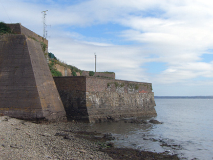 Cove FortFortification · 36 yd
 MertonOutbuilding · 122 yd
 Cork Harbour TragedyMemorial · 1049 yd
 Saint Colman's Cathedral, CobhCathedral · 1211 yd
 Titanic MemorialMemorial · 1279 yd
 CuskinnyBeach / strand · 1283 yd
 HaulbowlineIslet · 1.3 mi
.jpg/250px-Rocky_Island_(geograph_3666538).jpg "Photo: derek menzies, Wikimedia Commons · CC BY-SA 2.0") Rocky IslandIslet · 1.4 mi
Rocky IslandIslet · 1.4 mi Martello Tower1.5 mi
 Martello Tower2.1 mi
More archaeology and monuments in County Cork · All of County Cork
What do you know about this place?