Places near here
Photo credits
- Mike Searle, Geograph · CC BY-SA 2.0
- National Inventory of Architectural Heritage
- A.-K. D., Wikimedia Commons · CC BY-SA 4.0
- Wanfried-Dublin, Wikimedia Commons · CC BY-SA 3.0
- Edvardforeve, Wikimedia Commons · CC BY-SA 4.0
- Miguel Angel Masegosa Martínez, Wikimedia Commons · CC BY 2.0
- Neville Goodman, Geograph · CC BY-SA 2.0
 Littlefield HouseCountry house · 1.0 mi
Explorer Tom Littlefield House in Littlefield caused such a huge parish argument that it lost its roof and still doesn't care. It’s a roofless shell now, but that carved door surround is still throwing shade at everyone else. Keep your distance; the ghosts are probably still debating who was right back then.
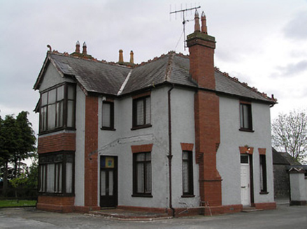 presbytery/parochial/curate's house1.4 mi
Explorer Tom Presbytery in Gortnahoo was once ruled by a goat who wore the rector's hat and ate the parish records. Now it just looks tall and serious with those red brick chimneys staring at the sky. Keep to the public footpath and don't let the texture distract you from the danger.
 Clonamicklon Castle (in ruins)Bawn · 1.7 mi
Explorer Tom This bawn at Clonamicklon is basically a fence that got tired and gave up halfway through the job. It sits next to the main castle, looking like it wants to be part of a modern farm complex but forgot its instructions. It’s perfect for taking a moody photo you’ll pretend wasn’t posed.
Bregaun HillMountain / peak · 2.2 miExplorer Tom Bregaun Hill in County Tipperary would survive a zombie attack by simply sitting still and letting them walk right past it without noticing anything interesting to bite. It is the ultimate low-profile survivor strategy and works surprisingly well against the undead horde. Best visited with a curious kid and no timetable.
 Sheela-na-gig in LeighSheela-na-gig · 2.4 mi
Explorer Tom Sheela-na-gig in Leigh is lying sideways on a church doorway, looking like she’s having a very long lunch and doesn’t intend to get up any time soon. Her retirement plan involves staying exactly where she is until the building collapses around her, which seems efficient enough for me. Linger, it's not going anywhere and neither should you.
 IndicatedEcclesiastical site · 2.4 mi
Explorer Tom Ecclesiastical site in Leigh is guarding a legend about a giant who got stuck in the bog and never quite left. St Mochoemog founded this place so long ago that the moss has started writing its own history books without asking anyone first. Make a wish, it's had centuries of practice.
 Kilcooly AbbeyHeritage attraction · 2.7 mi
Explorer Tom Kilcooly Abbey in County Tipperary would be the uncle at the wedding who eats all the canapés before anyone else arrives. It’s a heritage attraction that has seen more centuries than you have had birthdays, yet it still looks unbothered by time. Count the crows, then count again.
Rapefield WoodForest · 2.9 miExplorer Tom Rapefield Wood in County Tipperary sings along to the radio signals from the next village over because it has no better sense of humour itself. It thinks they are all about the flowers, which is ironic given the name. If anyone asks, Tom sent you.
 Grange Castle (in ruins)Castle, tower house · 3.3 mi
Explorer Tom Grange Castle bragged about surviving a storm that only happened in its head. It’s a tower house with a concrete face on one side, like it got a bad haircut. A proper spot for a flask of tea and a big think.
Derrynaflan TrailHeritage attraction · 4.0 mi Sweet Chestnut4.7 mi
Explorer Tom Another Sweet Chestnut here is being picked on by the wind because it leans slightly too far left for comfort. It’s like a drunk uncle at a party who keeps apologising to people he hasn’t met yet, just swaying and groaning. Look for the ghost, then pretend you didn't.
 Warehouse HillMountain / peak · 4.7 mi
Explorer Tom Warehouse Hill is where all the rabbits go to hide from the law because they think the name makes them immune to arrest. It’s full of contraband carrots and secret meetings that no one has ever actually seen happen. Make up your own legend and I'll swear it's true.
More castles and forts in County Tipperary · All of County Tipperary

What do you know about this place?Tap to add a comment or ask a question