
Places near here
Photo credits
- Colin Park, Geograph · CC BY-SA 2.0
- National Inventory of Architectural Heritage
- Ire2500, Wikimedia Commons · Public domain
- Colin Park, Wikimedia Commons · CC BY-SA 2.0
- Graham Horn, Geograph · CC BY-SA 2.0
- Andreas F. Borchert, Wikimedia Commons · CC BY-SA 4.0
- National Geospatial-Intelligence Authority, Wikimedia Commons · Public domain
- Keith Salvesen, Geograph · CC BY-SA 2.0
- Markbriggs, Wikimedia Commons · CC BY-SA 3.0
- Jonathan Wilkins, Geograph · Creative Commons Attribution-ShareAlike 2.0
 Clare Island Signal TowerRuins · 4 yd
Explorer Tom Clare Island Signal Tower would spend its lotto win on buying a loud megaphone to announce its existence to passing…
 Shivel Head Signal TowerSignal tower · 5 yd
Explorer Tom Shivel Head Signal Tower on Clare Island is another one of these silent sentinels from the early 1800s. It’s just…
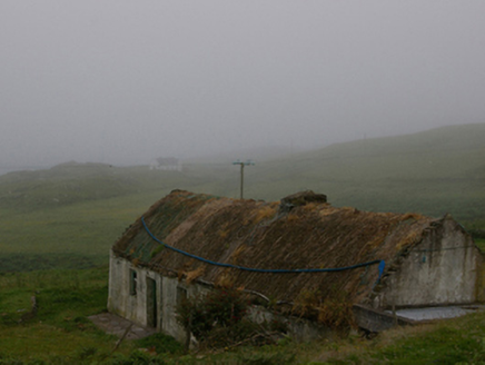 farm house1499 yd
Explorer Tom Farm house in Strake on Clare Island has a poet who fell in the ditch nearby as its main attraction. The thatch looks…
 KnockmoreMountain / peak · 1.2 mi
Explorer Tom Knockmore rises above Clare Island overlooking Clew Bay. This is the island's 462 metre high point, not the County Mayo…
 Clare IslandIsland · 2.0 mi
Explorer Tom I had barely stepped off the boat when Clare Island began testing my history lessons. Clare Island guards Clew Bay with…
 ScalpatruceMountain / peak · 2.0 mi
Explorer Tom Scalpatruce has a name that sounds like someone gargled gravel and then called it a day, which is probably why locals…
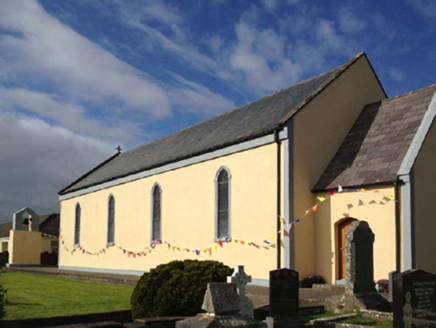 Catholic Church of the Sacred HeartChurch/chapel · 2.4 mi
Explorer Tom Catholic Church of the Sacred Heart on Clare Island hears everything through its thick walls, including your internal…
 AbbeyReligious house, Cistercian monks · 2.4 mi
Explorer Tom Abbey in Strake is a Cistercian relic on Clare Island that seems to have an unlikely celebrity friend who visits just…
 Achillbeg LighthouseLighthouse · 5.7 mi
Explorer Tom Achillbeg Lighthouse nearly got sold as a horse because a very confused farmer thought it looked like a very tall…
 The StrandBeach / strand · 19 mi
Explorer Tom The Strand is known to rearrange its own pebbles when nobody’s looking, just to see if anyone notices the subtle…
 Omey IslandIsland · 19 mi
Explorer Tom Omey likes to disappear behind Connemara's sand until the tide decides whether you may visit. The route from…
 ToberfeheenHoly well · 19 mi
Explorer Tom Toberfeheen in Gooreen is on an island, which means it’s got great separation issues and a solid excuse for being…
More archaeology and monuments in County Mayo · All of County Mayo

What do you know about this place?Tap to add a comment or ask a question