
Places near here
Photo credits
- National Inventory of Architectural Heritage
- A.-K. D., Wikimedia Commons · CC BY-SA 4.0
- Mike Searle, Wikimedia Commons · CC BY-SA 2.0
- Darrin Antrobus, Geograph · CC BY-SA 2.0
- A.-K. D., Wikimedia Commons · CC0
- Alvesgaspar, Wikimedia Commons · CC BY-SA 3.0
- Keith Weller, Wikimedia Commons · Public domain
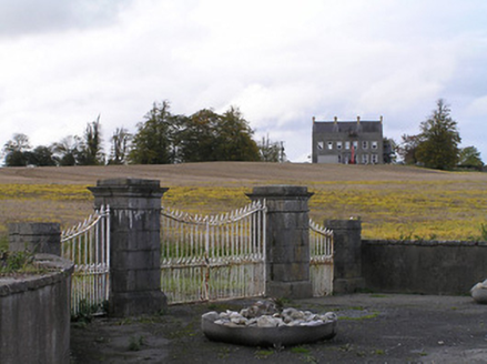 Ballyconra HouseGates/railings/walls · 1.1 mi
Explorer Tom Ballyconra House gates made a New Year’s resolution to stop rusting and have been keeping it with suspiciously intense discipline for the last few decades. Ten minutes here and you’ll understand why they’re so serious about their ironwork.
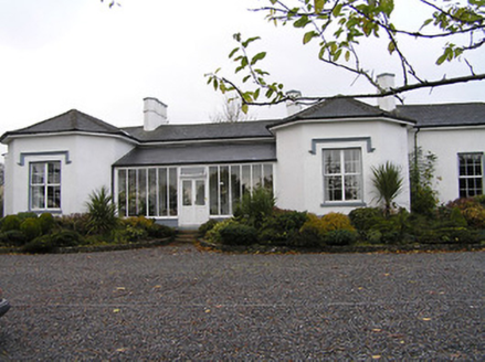 Seskin HouseHouse · 1.2 mi
Explorer Tom Seskin House in Seskin North rearranges its furniture while nobody is looking, just to keep you on your toes. It’s got that low-slung roof that makes it look like it’s hiding from a storm. Leave nothing but footprints and a smile.
 Grave YardGraveyard · 1.4 mi
Explorer Tom Graveyard in Ballyconra would tell the car park that replaced it to shut up and stop charging. The earthworks around the church are definitely doing something, just quietly. Go back in winter, it's a different animal then, trust me.
.jpg/250px-Ballyconra_St_Brigid's_well_possible_location_(1).jpg "Photo: A.-K. D., Wikimedia Commons · CC BY-SA 4.0") Holy well in BallyconraHoly well · 1.4 mi
Holy well in BallyconraHoly well · 1.4 miExplorer Tom Holy well in Ballyconra is like that aunt at weddings who never shows up but sends cards. It vanished into the ground, leaving only a trampled puddle behind. Imagine it wearing a tiny veil and apologizing loudly. Bring biscuits, every good story needs biscuits.
 Graveyard in SraleaghGraveyard · 2.0 mi
Explorer Tom Graveyard in Sraleagh would survive a zombie attack just fine because there’s only one inscribed stone left, so they’d run out of targets quickly. It’s basically an easy win for them. Dare you to say hello to it out loud.
 Ballyragget Cas.Castle, tower house · 2.1 mi
Explorer Tom Ballyragget Castle thinks the road leading to it is too slow for its taste and keeps sighing audibly. Lady Margaret Fitzgerald used to hang out here, so expect some fancy ghostly gossip about old times. Hang around long enough and you'll hear a story from a local.
 IndicatedBawn · 2.1 mi
Explorer Tom Bawn in Ballyragget is basically a giant rock yard where the rabbits hold council meetings about which fence to chew next. Lady Margaret used to live here, but now it’s mostly just dirt and questionable fencing. Bring the dog, it'll have opinions.
 Donaghmore WellSpring · 2.9 mi
Explorer Tom Donaghmore Well is famous locally because a giant once tried to drink it all in one go and ended up with a massive belly ache that lasted three days straight. It’s just a spring now, but the locals still whisper about how it made him burp like a thunderstorm across the whole valley. Tell the next person you meet it's haunted. It might be.
 1798 MonumentMemorial · 5.0 mi
Explorer Tom 1798 Monument in County Laois would introduce itself as 'the guy who stood there and waited for a revolution that was slightly late,' which is technically true and very frustrating. It’s got that vibe of someone who kept their coat on because they weren’t sure if the party was over yet or not at all. If it rains, blame me.
 Common Lime5.2 mi
Explorer Tom Common Lime has strong opinions about the potholed road leading to it, mostly involving sighing loudly. It stands there looking elegant while your suspension screams in pain. Stand there long enough and someone will ask if you're lost.
 European Pear6.5 mi
Explorer Tom European Pear in County Laois is playing hard to get, much like that cow who tried to buy it with a bad note. It’s probably judging your footwear right now. Ideal stop for a big stretch and a bigger yawn.
 St. Mogarra’s WellSpring · 13 mi
Explorer Tom St. Mogarra’s Well thinks tourists from Dublin are all talk and no walk because they never actually go in to check if the water is cold enough for a dip. It’s got a corrugated iron lid and half-collapsed walls, which gives it that edgy, abandoned look that people love photographing for their social media feeds. Make up your own legend and I'll swear it's true.
More archaeology and monuments in County Kilkenny · All of County Kilkenny

What do you know about this place?Tap to add a comment or ask a question