Places near here
Photo credits
- National Inventory of Architectural Heritage
- Mike Searle, Wikimedia Commons · CC BY-SA 2.0
- Ray Martin, Wikimedia Commons · Public domain
- Milesoneill, Wikimedia Commons · Public domain
- Mike-kinsella, Wikimedia Commons · CC BY-SA 4.0
- Richard Webb, Geograph · CC BY-SA 2.0
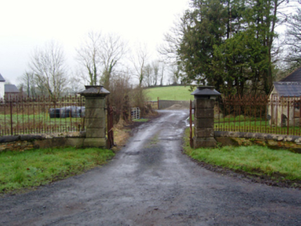 Rappa CastleGates/railings/walls · 889 yd
Explorer Tom Rappa Castle’s gateway is part of a neat little group that looks like it was built by someone who really liked symmetry and hated surprises. It sits at the entrance to the estate, doing its best to look dignified while the trees try to steal the spotlight in the background. The later nineteenth-century improvements mean it’s had a few facelifts, but it still manages to look like
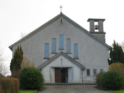 Catholic Church of Our Lady of the AssumptionChurch/chapel · 1062 yd
Explorer Tom Catholic Church of Our Lady of the Assumption in Brackloonagh is stuck in a feud with two families over who owns the view from the bellcote. It’s a Modernist masterpiece that probably doesn’t even know how funny this is getting. Pretext a phone call and just stand there looking thoughtful.
IndicatedEnclosure · 1305 ydExplorer Tom Enclosure in Derreen is where a priest once lost a bet about how high he could jump without landing in the mud. He lost, obviously, and now the spot is known for its excellent slipperiness. It’s a lesson in humility wrapped in a circle of wet earth. Find the date carved somewhere and feel clever.
_(geograph_1954385).jpg/250px-Castles_of_Connacht-_Deel,_Mayo_(1)_(geograph_1954385).jpg "Photo: Mike Searle, Wikimedia Commons · CC BY-SA 2.0") Deel CastleCastle · 1.2 mi
Deel CastleCastle · 1.2 miExplorer Tom Deel Castle claims it smuggled moonshine in barrels back in the day, but I suspect it just hid its own bad breath. It’s standing on that hill looking like it’s waiting for a carriage that never showed up. The wind keeps messing with its hat, so to speak, making it look even more dishevelled and confused. Ideal place to rehearse an excuse for being late.
 CastleCastle, tower house · 1.3 mi
Explorer Tom Castle in Deelcastle hosted a dance that went so far nobody remembers who started it. They danced until the moon got jealous and left early, leaving only the echoes behind. A proper spot for a flask of tea and a big think, mate.
 Battle of BallinaBattle · 2.8 mi
Explorer Tom The Battle of Ballina smells strongly of old boots, regret, and maybe a bit of stale bread if you get close enough to sniff. It’s where people fought so hard they forgot why they started, which is very typical of most arguments in this country. You can almost hear the echo of 'I told you so' bouncing off the rocks. Walk past slowly like you're in a film.
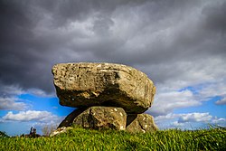 Dolmen of the four MaolsArchaeological place · 3.0 mi
Explorer Tom The Dolmen of the Four Maols stands on a low rise near Ballina, with three upright stones carrying a heavy capstone and another stone lying beside them. I asked the old table what it was serving today; the answer was a very old story and absolutely no lunch. Mayo County Council records this as the Ballina portal dolmen, a prehistoric tomb overlooking the River Moy. The name belongs to a much later local legend about four men called the Maols, linked to the killing of a bishop and their own deaths. The tale gives the monument its memorable name, but the stones were already ancient long before those events were imagined. Keep those two layers separate and both become more interesting. The capstone still balances on its supports, making a strong shape even in a setting close to a modern town and railway. One large fallen stone may once have been a fourth support. Look at the ground around the monument and the view towards the Moy, then picture how deliberately this place was chosen. If it seems like an odd spot for a prehistoric tomb now, remember that Ballina's streets arrived much later. The monument stands near Primrose Hill behind the railway station and is signposted as a protected site. Approach on public access, respect any boundaries and leave the stones undisturbed. It is a short visit with a long span of time in it. Give the Maols their legend, give the builders their much older work, and let neither steal the other's place.
Humbert MonumentMemorial · 3.3 miExplorer Tom Humbert Monument is standing guard with an escape plan that involves running into the sea if things get too political. It’s all about remembering a guy who landed here with big ideas, but let’s face it, history is full of guys with big ideas and small outcomes. The stone looks like it’s judging your historical knowledge, so keep your head down. Bring the dog, it'll have opinions.
 Belleek WoodsWood · 3.7 mi
Explorer Tom Belleek Woods claims Queen Victoria took a selfie here, but nobody has the photo, so you’re stuck believing it on faith. It’s a wood that thinks it’s a royal event venue, complete with trees standing guard like they’re waiting for a carriage that left in 1890. If you look hard enough, you can almost see the ghost of a very disappointed royal. Hang around long eno
FloretteWreck · 3.9 miExplorer Tom Florette is a wreck that looks like it got into a bit of a fight with the ocean and lost badly. It’s sitting there looking embarrassed, probably wishing it had taken the high road instead of the low tide route. The bargain price must have been worth something if you can still see the damage from here. Perfect detour when the satnav has a meltdown.
Rinphilip PointHeadland · 4.3 miExplorer Tom Rinphilip Point is definitely hiding a treasure that turns out to be nothing more than an empty biscuit tin from 1974 with some rust on it. The legend says it’s gold, but anyone who digs finds only disappointment and a bit of dirt on their shoes. It’s the ultimate bait-and-switch for adventure seekers looking for glory. Bring a pen pal, they'll be jealous.
Roe IslandIslet · 4.3 miExplorer Tom Roe Island in County Mayo is handling its nosy neighbors with the grace of a stone wall. It just sits there, watching you fumble around with your camera and looking unimpressed by your outfit. It’s got a thick skin and an even thicker silence. Stick around for the light changing, it's a show.
More archaeology and monuments in County Mayo · All of County Mayo

What do you know about this place?Tap to add a comment or ask a question