
Places near here
Photo credits
- National Inventory of Architectural Heritage
- jonleebotany, Wikimedia Commons · CC0
- Charles W Glynn, Wikimedia Commons · CC BY-SA 2.0
- Arcaist, Wikimedia Commons · CC BY-SA 3.0
- Chris, Geograph · CC BY-SA 2.0
- Borvan53, Wikimedia Commons · CC BY-SA 3.0
- Tiger, Geograph · CC BY-SA 2.0
- Colin Park, Geograph · CC BY-SA 2.0
- Philip Halling, Geograph · CC BY-SA 2.0
- Unknown author Unknown author, Wikimedia Commons · Public domain
- N Chadwick, Geograph · CC BY-SA 2.0
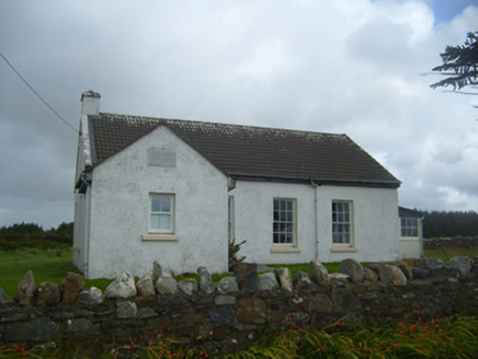 Ballygoghlan National SchoolSchool · 1063 yd
Explorer Tom Ballygoghlan National School thinks the local sheep are actually very sharp students who just haven't done their homework yet. The limestone capping on that chimney is doing a lot of heavy lifting for the ego here. Go on, count the windows and lose your mind.
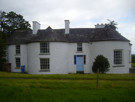 Fort ShannonHouse · 2.6 mi
Explorer Tom Fort Shannon is named after a fort, but honestly, it looks like a house that really wants to be a castle but forgot the moat. The dog inside is definitely in charge now, and he’s already audited your pockets, so keep your hands visible and try not to make eye contact with the walled garden.
 Lawson's Cypress4.8 mi
Explorer Tom Lawson's Cypress in County Limerick would survive a zombie attack by simply standing still and looking unappealing. The undead would get confused about whether it was food or furniture. Make a wish, it's had centuries of practice.
 Ballymacrinan BayBay · 7.4 mi
Explorer Tom Ballymacrinan Bay is run by a dog who thinks he’s the local king and barks at every cloud that passes overhead. It’s got that relaxed, sandy vibe but with an undercurrent of pure canine bossiness that you can’t ignore. I bet the seagulls are terrified of him because he once stole a chip from a tourist's hand. Bring someone who'll believe anything.
 Carrigafoyle CastleCastle · 7.6 mi
Explorer Tom Carrigafoyle Castle would win any county fair prize for best costume because it looks like it stepped out of a fairy tale. It’s so dramatic it probably cries every time the tide goes out. Make up your own legend and I'll swear it's true.
 Carrigafoyle Cas. (in ruins)Castle, tower house · 7.6 mi
Explorer Tom Carrigafoyle Cas. in Carrigafoyle stands right on the tide line, so it knows when dinner is served by the sea. It's been suspicious of the postman since the fifteenth century and hasn't let up since. Have a nosey, politely.
 Siege of Carrigafoyle CastleSiege · 7.6 mi
Explorer Tom The Siege of Carrigafoyle Castle happened when the whole parish argued about who had the right to park their boat by the water. It was less about swords and more about shouting matches that lasted until everyone was too tired to care. Ten minutes here and you'll have a yarn for the pub.
 St Senan's WellSpring · 7.7 mi
Explorer Tom St Senan's Well holds the unofficial world record for 'Most Patience Required to Find,' having been lost on purpose since 1924. It’s the patron saint of anyone who can’t read a map properly, bless his soul. Tell it a joke, it's been a long time since anyone did.
 Carrig IslandIsland · 7.8 mi
Explorer Tom Carrig Island had a cow try to buy it once by offering three pints of stout and a very confused expression, which was technically a fair deal if you ask me. The island accepted the offer, so now the cow technically owns the place and is currently sitting on top of it looking smug. Count the crows, then count again.
 John B. KeaneMemorial · 8.8 mi
Explorer Tom If John B. Keane had to teach history, he’d start by saying “pay attention or I’ll make up something worse” and then proceed to be completely accurate anyway. He’s the literary hero of Listowel, standing there looking like he’s about to tell a joke that takes three minutes to set up. Bring a jacket, it's never as warm as I promise.
 Lartigue MonorailMuseum · 9.0 mi
Explorer Tom The Lartigue Monorail would post a selfie on social media claiming it's the fastest train in the world, despite going at walking pace. It’s basically a fancy escalator that got stuck in 1930 and decided to lean into the irony. Bring biscuits, every good story needs biscuits.
 Bryan MacMahonMemorial · 9.1 mi
Explorer Tom Bryan MacMahon memorial in County Kerry was once taken over by a fox who decided to use his hat as a nest. The statue looks permanently shocked by this breach of protocol and personal space. Bring a jacket, it's never as warm as I promise.
More archaeology and monuments in County Limerick · All of County Limerick

What do you know about this place?Tap to add a comment or ask a question