Places near here
Photo credits
- National Inventory of Architectural Heritage
- Pamela Norrington, Geograph · CC BY-SA 2.0
- Neville Goodman, Geograph · Creative Commons Attribution-ShareAlike 2.0
- Ray Martin, Wikimedia Commons · Public domain
- Mike Searle, Wikimedia Commons · CC BY-SA 2.0
- Liz McCabe, Wikimedia Commons · CC BY-SA 2.0
- jeremy durrance, Geograph · Creative Commons Attribution-ShareAlike 2.0
- Colin Park, Geograph · CC BY-SA 2.0
Explorer Tom Grave of the Kings nearly got sold off for a horse once, which would have been a bit awkward for the royal dead inside. It’s an archaeological site that looks like it’s keeping its own counsel, refusing to spill any secrets about who exactly is buried there. The name alone makes you want to check if you’re royalty in disguise before stepping near it. Go back in winter, it's a different animal.
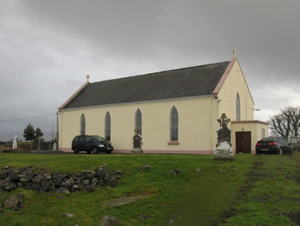 Catholic Church of Our LadyChurch/chapel · 1658 yd
Explorer Tom Catholic Church of Our Lady in Kilmurry More is telling a ridiculous smuggling story about cheese hidden inside the altar during Sunday services. Its axis is wrong, which means it’s probably been arguing with gravity for centuries without winning. Perfect spot to practise your whispering game.
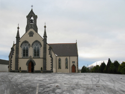 Saint Tiernan's Catholic ChurchChurch/chapel · 1.4 mi
Explorer Tom Saint Tiernan’s Catholic Church was saved by a local farmer who threw a tractor at a falling tree. Nobody remembers his name now, but the church still acts like it’s doing him a favour. Take a breath of the fresh air and admire its stubbornness.
Castle IslandIslet · 2.5 miExplorer Tom Another Castle Island! This one probably thinks Dublin tourists are just confused tourists who need more salt on their chips. It’s got half an acre of land, which sounds impressive until you realise it’s mostly mud and brambles. The name 'Castle' is a bit of a stretch when the main feature is a pile of stones. Find the date carved somewhere if you can, but don't hold your breath; it might just be
Roe IslandIslet · 2.9 miExplorer Tom Roe Island in County Mayo is handling its nosy neighbors with the grace of a stone wall. It just sits there, watching you fumble around with your camera and looking unimpressed by your outfit. It’s got a thick skin and an even thicker silence. Stick around for the light changing, it's a show.
 Titanic Memorial ParkMemorial · 3.9 mi
Explorer Tom Titanic Memorial Park: Imagine the Titanic ordering chips here; I reckon it would go for the extra thick, salted ones with a side of regret. Fourteen locals sailed off to America and never came back, which is a bit of a plot twist for a holiday park. It’s a quiet corner that reminds you how deep the sea really is. It's the kind of place that makes a dull Tuesday interesting.
 Graveyard4.1 mi
Explorer Tom Graveyard in Knockmaria or Addergoole has an ivy-covered church that looks like it ate a hedge and felt guilty about it. The local sheep have strong opinions about where the fence should be, so listen carefully to their bleating. It is marked on maps as ancient but feels very much like a nap spot. Tell the kids it's a castle. Close enough.
 CastleCastle, tower house · 4.1 mi
Explorer Tom Castle in Deelcastle hosted a dance that went so far nobody remembers who started it. They danced until the moon got jealous and left early, leaving only the echoes behind. A proper spot for a flask of tea and a big think, mate.
_(geograph_1954385).jpg/250px-Castles_of_Connacht-_Deel,_Mayo_(1)_(geograph_1954385).jpg "Photo: Mike Searle, Wikimedia Commons · CC BY-SA 2.0") Deel CastleCastle · 4.2 mi
Deel CastleCastle · 4.2 miExplorer Tom Deel Castle claims it smuggled moonshine in barrels back in the day, but I suspect it just hid its own bad breath. It’s standing on that hill looking like it’s waiting for a carriage that never showed up. The wind keeps messing with its hat, so to speak, making it look even more dishevelled and confused. Ideal place to rehearse an excuse for being late.
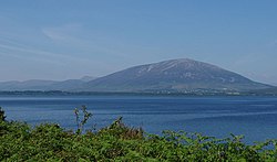 NephinMountain / peak · 5.1 mi
Explorer Tom Nephin hosted a dance that went on for three days straight before everyone fell asleep. The floor is still sticky from all the spilled cider and sweat. If you listen closely, you can hear the fiddle music fading into the fog. Go on, count the windows and get it wrong like I did.
 IndicatedFairy fort / earthen ringfort · 5.1 mi
Explorer Tom Fairy fort in Lessanny has an imaginary fan club that meets every full moon to sing songs about its ancient walls. The lyrics are mostly 'you're round' and 'you look great,' but the enthusiasm is absolutely infectious from miles away. Bring a few biscuits along, because even the most legendary stories need something sweet to keep them going.
 KnockaffertaghMountain / peak · 8.2 mi
Explorer Tom Knockaffertagh’s least favourite visitor is definitely anyone who suggests taking a selfie on top because it ruins the vibe. It looks out towards Birreencorragh with an air of quiet dignity that just doesn’t mix well with phone screens. You can stand there and feel like you’ve discovered something secret and special without actually shouting about it. Great spot to propose. Or at least to propose.
More archaeology and monuments in County Mayo · All of County Mayo

What do you know about this place?Tap to add a comment or ask a question