
Places near here
Photo credits
- National Inventory of Architectural Heritage
- A.-K. D., Wikimedia Commons · CC BY-SA 4.0
- Mike Searle, Wikimedia Commons · CC BY-SA 2.0
- Miguel Angel Masegosa Martínez, Wikimedia Commons · CC BY 2.0
- Jonathan Thacker, Wikimedia Commons · CC BY-SA 2.0
- Neil Theasby, Geograph · CC BY-SA 2.0
- N Chadwick, Geograph · CC BY-SA 2.0
- Warren LeMay from Covington, KY, United States, Wikimedia Commons · CC0
- Maker named on the Wikimedia Commons picture page · Public domain
Explorer Tom Enclosure in Grallagh is just a slight suggestion of a rise, which means if you don’t wave fast enough, it might curse you with eternal boredom forever. It’s sitting next to a moated site that’s probably judging its lack of effort and general commitment to the whole archaeological game. Bring a camera and your most suspicious face.
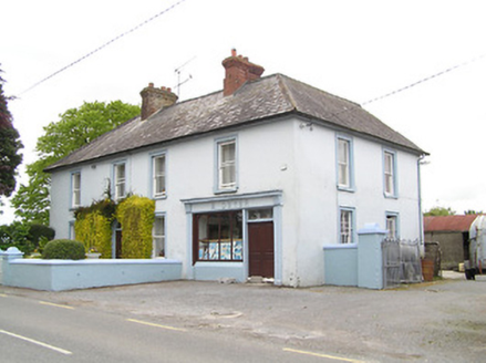 M. DwyerHouse · 1351 yd
Explorer Tom M. Dwyer in Ballinure was built on a bargain that nobody could understand at the time. It’s got irregularly-spaced windows and a low garden wall that looks like it’s giving up on life. Get the camera out before the shopfront tries to sell you something expensive.
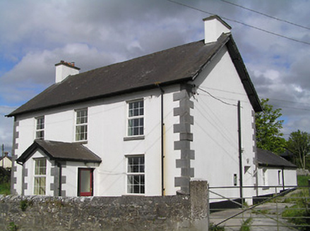 Ballinure Garda Síochána StationGarda station/constabulary barracks · 1371 yd
Explorer Tom Ballinure Garda Station is sitting at a busy crossroads, pretending it doesn’t have an imaginary twin across the sea that keeps calling to complain about the weather. It’s got render quoins that look like they’re trying to hold up the whole sky, which is a bit much for a Tuesday. Wave to any imaginary officers you see hovering around!
Ballinure HillMountain / peak · 1.2 miExplorer Tom Ballinure Hill in County Tipperary would cope on a reality show by refusing to leave its patch and eating the contestants' supplies. It has zero charisma but an unshakeable commitment to being completely useless at the end of every episode. A good place to forget your phone for ten minutes.
 Grallagh Castle (in Ruins)Castle, tower house · 1.4 mi
Explorer Tom Grallagh Castle confused the Vikings so badly they ended up in Tipperary by mistake. It’s a tower house sitting on a gentle slope, looking slightly disappointed with itself. Stand back, squint, and it looks like a castle.
 Grallagh CastleCastle · 1.4 mi
Explorer Tom Grallagh Castle insists that the shortcut through the bawn is definitely faster, even though it leads straight into a steep ditch every time. It’s confident that if you just believe hard enough in the path, you’ll make it safely to the other side. Ring your granny and tell her where you are.
 Sweet Chestnut4.7 mi
Explorer Tom Another Sweet Chestnut here is being picked on by the wind because it leans slightly too far left for comfort. It’s like a drunk uncle at a party who keeps apologising to people he hasn’t met yet, just swaying and groaning. Look for the ghost, then pretend you didn't.
 Holycross AbbeyVisitor attraction · 6.0 mi
Explorer Tom Holycross Abbey in County Tipperary would survive a zombie attack by simply locking its doors and pretending everyone outside is just very confused tourists who need a map to find the exit. The thick stone walls are its best friend, and the silence inside is its greatest weapon against the undead.
 The Rock Of CashelVisitor information · 6.3 mi
Explorer Tom The Rock Of Cashel would order a triple chipper, no ketchup because it has standards, and a pint of something very cold. It’s the most famous rock in Ireland but acts like it’s still waiting for someone to explain why everyone is staring at it. Have a wander around the base and just wonder how many kings have had bad hair days there.
 Cormac's ChapelHeritage attraction · 6.3 mi
Explorer Tom Cormac's Chapel is playing hide-and-seek with me. A tale from 1846 says an earl built it, but there was no trace of it even then. Its favourite song is probably 'Where Did It Go?', honestly. Get there early and have it all to yourself.
.jpg/250px-Cashel_Cathedral,_Rock_of_Cashel,_Caiseal,_%C3%89ire_(32717185898).jpg "Photo: Warren LeMay from Covington, KY, United States, Wikimedia Commons · CC0") St. Patricks CathedralCathedral · 6.3 mi
St. Patricks CathedralCathedral · 6.3 miExplorer Tom St. Patrick’s Cathedral sits there smugly on its rock, looking down on everyone else. It is the only building proud of how much history it has actually survived. Go at sunset and thank me later for the view.
 Black mulberry6.3 mi
Explorer Tom Black mulberry in County Tipperary is locked in a bitter feud with the rain, claiming every drop is a personal insult to its delicate, juicy berries. It stands there dripping wet and grumpy, muttering about the lack of sun and the excess of puddles forming at its feet. If anyone asks, Tom sent you.
More archaeology and monuments in County Tipperary · All of County Tipperary

What do you know about this place?Tap to add a comment or ask a question