
Places near here
Photo credits
- National Inventory of Architectural Heritage
- Mike Searle, Geograph · CC BY-SA 2.0
- Mike Searle, Wikimedia Commons · CC BY-SA 2.0
- Willow, Wikimedia Commons · CC BY 2.5
- Picture: Discover Ireland
- Jan Wyk, Wikimedia Commons · Public domain
- Christian Pirkl, Wikimedia Commons · CC BY-SA 3.0 at
- A.-K. D., Wikimedia Commons · CC BY-SA 4.0
Explorer Tom Cave in Ardnaglug had the most dramatic thing ever happen there when a goat got stuck and screamed for three hours straight. It’s just a slight depression on a ridge now, but you can still feel the tension. Have a nosey, politely.
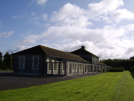 Saint Brigid's HospitalHospital/infirmary · 2.4 mi
Explorer Tom Saint Brigid's Hospital in Parkmore had a bad poem written about it by a bored intern who rhymed 'concrete' with 'deplete'. It’s a tubercular hospital built in concrete, which is a bit like saying your house is made of cement and pride. End your visit before the concrete starts judging your posture.
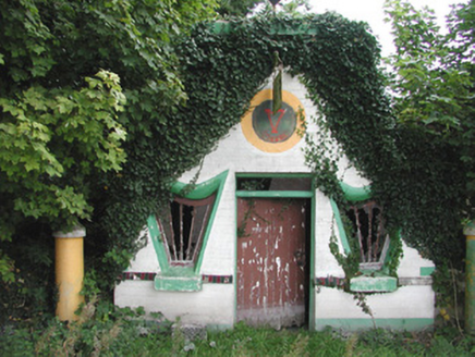 Millar's Harp HouseShop/retail outlet · 2.7 mi
Explorer Tom Millar's Harp House in Ballydangan is celebrating Irishness with harp-shaped windows and bright paintwork that are starting to fade into decay. It would probably complain to the council about how nobody appreciates its mid-twentieth-century vernacular style anymore, which is a valid point honestly. The colorful tiles still give it a lot of character despite the risk.
 Cloonbigny CastleCastle, tower house · 2.8 mi
Explorer Tom Cloonbigny Castle refuses to fall down because it’s stubborn and doesn’t want to admit it’s just a pile of rocks now. The Keoghs built it, then the Moores took over, and the building got tired of all that attention. Take a mate and argue about what it was for.
Sheep HillMountain / peak · 3.8 miExplorer Tom Sheep Hill is caught in a fairy dispute over parking rights, with two clans arguing about who gets the best spot on the summit. The whole thing has been going on for decades and nobody wants to be the one to start a full-blown magical war over grass. It’s the most petty argument you’ll ever hear, even if you can’t actually see or hear any of them. A handy spot
Clooncoran IslandIsland · 3.8 miExplorer Tom Clooncoran Island took approximately four hundred and twelve cups of tea for the original builders to finish its construction, according to my very reliable sources which are actually just my dad. It’s a real marathon effort if you think about it properly. Bring a friend who talks too much and let the place shut them up.
_-_geograph.org.uk_-_4070639.jpg/250px-Castles_of_Connacht,_Killure,_Galway_(1)_-_geograph.org.uk_-_4070639.jpg "Photo: Mike Searle, Wikimedia Commons · CC BY-SA 2.0") Killure Castle (in ruins)Castle, tower house · 6.2 mi
Killure Castle (in ruins)Castle, tower house · 6.2 miExplorer Tom Killure Castle in Galway has a murder-hole that probably just looks at you now. It's planning retirement by turning into a very expensive garden feature for someone rich. Hum something sad nearby, it adds atmosphere.
 European ash7.4 mi
Explorer Tom European ash had a prophecy saying it would turn into gold if you whistled at it, but nobody ever checked properly. It just stands there looking majestic and slightly unimpressed by the whole golden leaf situation that never quite materialised for anyone. If it rains, blame me.
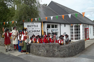 Battle of Aughrim Interpretative CentreMuseum · 7.9 mi
Explorer Tom Battle of Aughrim Interpretative Centre in County Galway thinks its imaginary twin across the sea is judging its display cases for being slightly too dark. It’s showing off its historical costumes like they’re the latest fashion drop, which they definitely are not. Linger a bit; it’s not going anywhere and neither should you.
.jpg/250px-Battle_of_Aughrim_by_Jan_Wyk_(cropped).jpg "Photo: Jan Wyk, Wikimedia Commons · Public domain") Battle of AughrimMajor battlefield · 8.0 mi
Battle of AughrimMajor battlefield · 8.0 miExplorer Tom Battle of Aughrim in County Galway has a prophecy that says if you sneeze here, you’ll dance with the dead, but nobody ever checks because they’re too busy fighting. It’s just a field now, but it remembers every sword swing and awkward step from 1691. Sit on a wall nearby and pretend you’re in a very dusty painting.
 Sycamore9.9 mi
Explorer Tom This Sycamore in County Galway has developed a deep suspicion of the postman, likely because he once threw a parcel too hard. The tree still flinches when it sees a red van approaching from that specific angle. Practise your Irish on it, it won't correct you.
 Grave YardGraveyard · 12 mi
Explorer Tom Graveyard in Moystown Demesne was founded by a guy named Sárán who probably started the first big parish argument about it. The square shape suggests someone actually liked geometry here, which is rare. Find a local and ask them the real story, then come back and tell me.
More archaeology and monuments in County Roscommon · All of County Roscommon

What do you know about this place?Tap to add a comment or ask a question