
What is recorded here
In cut-away bogland on an upland terrace on a ridge extending to the W from the 12 Bens mountain range with panoramic views all round, overlooking Roundstone bog and Árainn to the S, Clifden to the W and the mountains to the E. Recorded by M. Gibbons, this possible stone hut site (4.5m NE-SW; 3m NW-SE), roughly…
Read the whole record
From the National Monuments Service (Archaeological Survey of Ireland) record GA036-024
Places near here
Photo credits
- Nigel Thompson, Geograph · CC BY-SA 2.0
- Newbert12, Wikimedia Commons · CC BY-SA 4.0
- National Inventory of Architectural Heritage
- Joseph Mischyshyn, Wikimedia Commons · CC BY-SA 2.0
- Maker not stated on source page, commons.wikimedia.org
- Maker not stated on source page, tr.pinterest.com
- Maker not stated on source page, www.pinterest.com
- Didier Descouens, Wikimedia Commons · CC BY-SA 4.0
- Maker named on the Wikimedia Commons picture page · Public domain
- Maker not stated on source page, www.flickr.com
- Maker not stated on source page, uk.pinterest.com
 CrannogIslet · 800 yd
Explorer Tom Crannog has strict rules for visitors: no talking louder than a whisper, no touching the ancient wood, and absolutely…
 Ballynahinch Church (Moyrus)Church/chapel · 1.4 mi
Explorer Tom Ballynahinch Church (Moyrus) in Emlaghdauroe is sitting in a landscape that looks like it was made by a grumpy god. The…
 Ballynahinch CastleFarmyard complex · 2.1 mi
Explorer Tom Ballynahinch Castle is a farmyard complex pretending it’s a fortress because Saint Patrick said it looked too fancy for…
 Fairy fort / stone ringfort in BallynahinchFairy fort / stone ringfort · 2.2 mi
Explorer Tom Fairy fort in Ballynahinch had a feud with the next village over who got to keep the bigger boulder. They settled it by…
 Castle (in Ruins)Castle, tower house · 2.2 mi
Explorer Tom Ballynahinch Castle sits on an island in a lake, which means it’s technically unreachable unless you swim with a torch.…
 Standing stone in BallynahinchStanding stone · 2.6 mi
Explorer Tom Ballynahinch is keeping its secrets tight; nobody knows much about this stone except that it exists and is probably…
 Standing stoneStanding stone, pair · 2.6 mi
Explorer Tom There’s a pair of stones in Ballynahinch that were found after clearing some rhododendrons. They’re standing close…
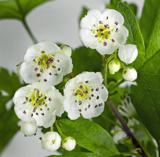 Hawthorn2.8 mi
Explorer Tom The Hawthorn in County Galway has a secret talent for hiding acorns from squirrels that are actually just shiny…
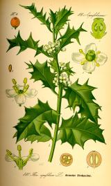 English holly2.8 mi
Explorer Tom English holly treats nosey neighbours with a spine, literally, because one wrong step and you’re crying on the grass.…
 Fairy fort / stone ringfort in LetterdifeFairy fort / stone ringfort · 3.9 mi
Explorer Tom Fairy fort / stone ringfort in Letterdife is a subrectangular artificial island in Loch Caimín, with traces of a…
 Station House MuseumMuseum · 4.5 mi
Explorer Tom Station House Museum in County Galway thinks the road leading to it is the most boring thing since sliced bread. It…
 Summer IslandIslet · 5.1 mi
Explorer Tom Summer Island was built by a guy who really wanted to capture the essence of July in stone, which was ambitious for a…
More archaeology and monuments in County Galway · All of County Galway

What do you know about this place?Tap to add a comment or ask a question