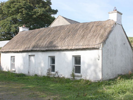
What is recorded here
Detached four-bay single-storey vernacular house, built c. 1850. Pitched thatched roof with smooth rendered chimneystacks to gables with coping. Roughcast rendered walls with recessed smooth rendered plinth course. Square-headed window openings with patent rendered surrounds, one-over-one horned timber sash windows,…
Read the whole record
From the Buildings of Ireland (National Inventory of Architectural Heritage) record 40901306
Places near here
Photo credits
- Corinna Schleiffer, Wikimedia Commons · CC BY-SA 2.0
- N Chadwick, Geograph · CC BY-SA 2.0
- Malcolm Neal, Geograph · CC BY-SA 2.0
- Kenneth Allen, Wikimedia Commons · CC BY-SA 2.0
- N Chadwick, Wikimedia Commons · CC BY-SA 2.0
- Patrick Mackie, Geograph · CC BY-SA 2.0
- Kay Atherton, Wikimedia Commons · CC BY-SA 2.0
- Michael Dibb, Wikimedia Commons · CC BY-SA 2.0
- Rossographer, Geograph · CC BY-SA 2.0
 Inishowen LighthouseLighthouse · 624 yd
Explorer Tom Inishowen Lighthouse began guiding ships into Lough Foyle in 1837 with twin granite towers. A local tale says a keeper's geese escaped to Greencastle and ended up in a family's Christmas meal. The lights guided ships; the geese apparently needed no help finding a route.
Stroove LighthouseLighthouse · 626 ydExplorer Tom Stroove Lighthouse stands exactly 153 yards from its partner, which feels like a very serious game of tag. I picture them holding hands across that gap, refusing to let any ship wander off into the mist.
 StrooveOfficial bathing water · 673 yd
Explorer Tom Stroove Beach has two lighthouses for neighbours, which is a lot of competition for a small shore. The sand is the reason for this stop, not the towers. I might ask the towers to mind my place while I take my litter home, as Donegal tourism asks visitors to do.
 Michael John's PubPub · 709 yd
Explorer Tom Michael John’s Pub has two first names, so it’s basically a committee. Ask Michael who John is. He’ll probably say he’s his brother. Suspicious.
 Dunagree PointHeadland · 878 yd
Explorer Tom Dunagree Point carries the twin granite towers of Inishowen Lighthouse. The lighthouse account says its rear tower was raised by 7.6 metres to improve visibility on Lough Foyle. I can almost hear the headland saying, “I stayed put while the tower did the stretching.”
 Cliffs, Inishowen HeadPublicly named cliff or headland · 1181 yd
Explorer Tom Inishowen Head’s cliffs guard the edge of the world, but remember that a public photo doesn’t mean free entry.
 White StrandBeach / strand · 1236 yd
Explorer Tom White Strand near Lough Foyle offers a pale, quiet corner where the gentle waters meet the shoreline.
 Port a Dorais Cave and Natural DoorSea cave and natural arch · 1389 yd
Explorer Tom Port a Dorais features a natural rock arch door under Inishowen Head, about one and a half kilometres from Stroove beach.
_-_geograph.org.uk_-_5506767.jpg/250px-Grencastle_Fort_(2)_-_geograph.org.uk_-_5506767.jpg "Photo: Michael Dibb, Wikimedia Commons · CC BY-SA 2.0") Greencastle Martello FortCastle · 2.1 mi
Greencastle Martello FortCastle · 2.1 miExplorer Tom Greencastle Martello Fort was built to stop Napoleon from wading in. I can’t help but imagine him slipping on a wet rock and sliding all the way down to Derry with his hat flying off.
 Greencastle / Northburgh CastleCastle, Anglo-Norman masonry castle · 2.1 mi
Explorer Tom Greencastle / Northburgh Castle was built by the Red Earl in 1305 to guard the shore, and it’s still standing tall on its rocky perch. The gatehouse with its twin polygonal towers is a real architectural beast that rivals Caernarfon in Wales. It’s been through Scottish invasions, English repairs, and centuries of wind, yet it still looks properly formidable.
 Martello tower on magilligan point in Doaghs LowerMartello Tower on Magilligan Point · 2.6 mi
 CrockaulinMountain / peak · 3.2 mi
Explorer Tom Crockaulin offers a lonely triangulation pillar that stares down at Greencastle from a dizzying height. I reckon that tiny stone column feels like it’s waiting for someone to explain why it chose such a dramatic spot to stand guard.
More historic places in County Donegal · All of County Donegal

What do you know about this place?Tap to add a comment or ask a question