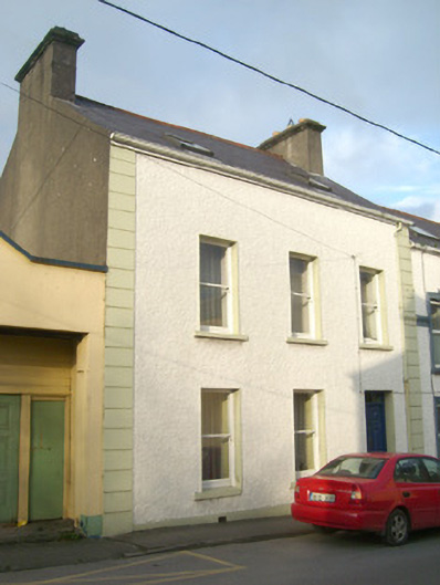
Places near here
Photo credits
- National Inventory of Architectural Heritage
- Kenneth Allen, Geograph · CC BY-SA 2.0
- Andreas F. Borchert, Wikimedia Commons · CC BY-SA 4.0
- David Dixon, Wikimedia Commons · CC BY-SA 2.0
- louise price, Wikimedia Commons · CC BY-SA 2.0
- louise price, Geograph · CC BY-SA 2.0
- Malene Thyssen, Wikimedia Commons · CC BY-SA 3.0
- Rossographer, Geograph · CC BY-SA 2.0
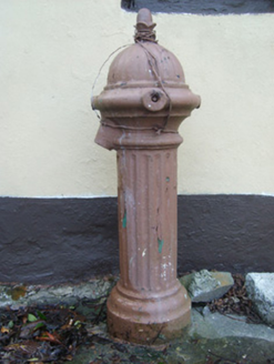 water pump38 yd
Explorer Tom Water pump in Killybegs has an acorn finial that looks like a tiny, very serious hat. Built around 1910 by Glenfield & Kennedy Ltd, it stands in a laneway pretending to be a royal guard. I bet it’s checking every passersby’s posture with that domed cap.
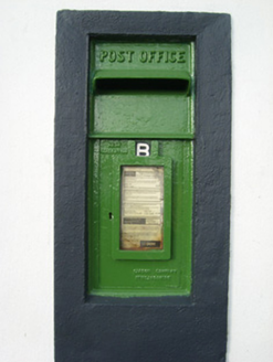 post box65 yd
Explorer Tom Post box in Killybegs sports a 'Carron Company' stamp from Scotland, which makes it feel like a stubborn Scottish immigrant refusing to change its accent. Maybe it still expects letters addressed to Stirlingshire, just waiting for a very confused postman to deliver them.
 HughiesPub · 110 yd
Explorer Tom Hughies in Killybegs is where locals feel like kings, even if nobody knows who Hugh actually was. It would survive a zombie attack by hiding behind the strong pints. It's the kind of place that makes a dull Tuesday interesting.
 Harbour BarPub · 249 yd
Explorer Tom Harbour Bar probably smells like old fish and bad decisions, because that’s what 'harbour' really means in this context. I’d grab a stool and listen to stories they don’t tell on TV. Ideal spot for a dramatic phone call.
 St Catherine's Friary GraveslabGraveslab · 944 yd
Explorer Tom St Catherine's Friary Graveslab marks John Lindsey, who died young at twenty-seven back in 1685. The slab is broken and its coat of arms has vanished, leaving just the incised Roman script to tell his story. It’s a bit sad that the family crest got lost, but the words remain.
 St Catherine's WellHoly well · 1022 yd
Explorer Tom St Catherine's Well in Killybegs was once a famous pilgrimage site, but there’s a daft legend that a Protestant rector tried to fill it up with dirt. The next day, a spring burst into his drawing room, terrifying his wife until he reopened the well. It’s still cleaned for St. Catherine’s Day, sitting beside the ruins of 'Cat Castle' in marshy pasture.
 Cat CastleCastle, tower house · 1073 yd
Explorer Tom Cat Castle is named after St. Catherine, but really it’s just a tiny stone corner standing on a hill above Killybegs Harbour. It’s been shrinking since 1355, and now only a 3-metre wall survives. It’s a bit pathetic, sure, but looking out over the harbour makes you wonder what that bishop’s manor looked like when it was whole.
 Rashenny PointHeadland · 1.1 mi
Explorer Tom Rashenny Point in County Donegal was once the prime spot for smuggling contraband teacups and very suspiciously large turnips right under the noses of the taxmen. The cliffs still look like they’re holding their breath, waiting for the next batch of illegal vegetables to arrive. Bring curiosity, leave with a better story than mine.
 Rotten IslandIslet · 1.5 mi
Explorer Tom Rotten Island sounds like a pirate's insult, but its lighthouse story is serious. The light guides boats into Killybegs Harbour; three workers drowned returning from the island while it was being built. I would remember them whenever that white tower comes into view.
 Carntullagh HeadHeadland · 1.6 mi
Explorer Tom Carntullagh Head is a rugged County Donegal point that apparently doubles as a fish farm. I imagine the wild seabirds looking down at their new plastic neighbours with mild confusion, wondering if this is still the natural order of things.
 European Beech1.6 mi
Explorer Tom European Beech in County Donegal is a tree that pretends to be from somewhere warmer but lives here anyway. Vikings once got lost looking for it and ended up in a bog instead, which was definitely not their fault. Give it a respectful wave; don’t lean on it, it’s old and grumpy.
 FintraOfficial bathing water · 1.7 mi
Explorer Tom Fintra gives me a grand view before I reach the sand: the road drops toward Donegal Bay, with dunes and grassy hills behind the shore. There is a lagoon at the far end from the car park. I would let someone else call that steep, narrow road a quick nip down.
More historic places in County Donegal · All of County Donegal

What do you know about this place?Tap to add a comment or ask a question