What is recorded here
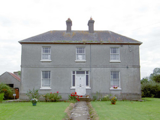
Detached three-bay two-storey house, built c. 1890. Possibly incorporating the fabric of an earlier building to site. Hipped natural slate roof with central pair of rendered chimneystacks. Roughcast rendered walls to first floor with smooth rendered walls to ground floor separated by smooth rendered platband. Projecting smooth rendered plinth. Square-headed window openings with one-over-one pane timber sliding sash windows having margin glazing. Central square-headed door opening with timber panelled door with overlight and sidelights. Set back from road in own grounds to the west of Keenagh. Single-storey outbuilding to southeast with pitched corrugated-metal roof and roughcast rendered walls. Rendered boundary wall to road-frontage to the northeast. Pedestrian gateway to the northeast of house comprising a pair of rendered gate piers (on square-plan) having a wrought-iron flat bar gate.
This simple late-nineteenth or early-twentieth century house retains its original character and form. The modest façade of this well-proportioned building is arranged symmetrically with central doorway creating a pleasing appearance. It represent a late example of the enduring popularity of the three-bay two-storey house with central doorway in rural Ireland, examples of which can be found dating from the mid-eighteenth to the mid-twentieth century. It retains its early fabric including a timber panelled door and timber sliding sash windows with margin glazing. The contrast between the smooth and roughcast rendered finishes to the front elevation creates an interesting textural and tonal effect. The simple wrought-iron gate adds to the setting and completes this composition. This building is prominently sited along the main approach road to Keenagh from the west, and is an addition to the built heritage of the local area. The present house occupies the site of an earlier building (Ordnance Survey first edition six-inch map 1838) and some of the outbuildings to the rear might be associated with this earlier building (or could be converted dwellings).
This does not grant access. Most recorded buildings are privately owned; view them only from public ground unless the owner allows entry.
Places near here
 IndicatedFairy fort / earthen ringfort · 408 yd
 RoadRoad, class 3 togher · 689 yd
 StructureStructure, peatland · 697 yd
 water pumpwater pump · 1360 yd
 Corlea Bog Walk Blue LoopWalking route · 1.4 mi
 Corlea Trackway Interpretative CentreHeritage attraction · 1.7 mi
 Corlea Bog Walk Canal BranchWalking route · 2.0 mi
 Caltragh CastleCastle, unclassified · 2.6 mi
 Elfeet CastleCastle, Anglo-Norman masonry castle · 3.9 mi
 Culnagore WoodForest · 4.1 mi
 Bush IslandIslet · 4.3 mi
 Elfeet BayBay · 4.4 mi
Other information
Photo: National Inventory of Architectural Heritage · Website use allowed for educational or private purposes with source credit