
Places near here
Photo credits
- National Inventory of Architectural Heritage
- A McCarron, Wikimedia Commons · CC BY-SA 2.0
- Kenneth Allen, Geograph · CC BY-SA 2.0
- Anne Burgess, Wikimedia Commons · CC BY-SA 2.0
- louise price, Geograph · CC BY-SA 2.0
- Joseph Mischyshyn, Wikimedia Commons · CC BY-SA 2.0
- Mac McCarron, Geograph · CC BY-SA 2.0
- Mhdelaney, Wikimedia Commons · CC BY-SA 4.0
- Eric Jones, Geograph · CC BY-SA 2.0
- Bart Whelan, Wikimedia Commons · CC BY-SA 2.0
 Lop 74Watch tower · 1018 yd
Explorer Tom Lop 74 was a small coast watch hut erected around 1941, with a canted western half and a fireplace. From its elevated site it overlooked the Atlantic. It is small, but it had a long view to keep.
 Crohy TowerSignal tower · 1235 yd
Explorer Tom Crohy Tower was built around 1805 as part of a coastal signal network watching for a possible French invasion. I would have needed enormous patience at that job; every cloud on the Atlantic would be trying to convince me it was a ship.
 Lough Aghnish Promontory FortPromontory fort, inland · 1709 yd
Explorer Tom Lough Aghnish Promontory Fort cuts off a peninsula with a stone wall that has a weird, angled entrance. The base is solid, but the top looks like modern repairs. It’s a bit of a puzzle why they built it exactly there.
 Strand View BarPub · 1.2 mi
Explorer Tom Strand View Bar probably has a view of the sea and a lot of people staring at it. It's in Donegal, where the wind tries to steal your hat. Go look out the window and feel majestic.
 CroaghnamaddyMountain / peak · 2.2 mi
Explorer Tom Croaghnamaddy in County Donegal is basically just a very arrogant hill that thinks it's a mountain. I'd bet my last pint there's a secret bakery up there, so bring biscuits, every good story needs biscuits.
 DooeyOfficial bathing water · 3.5 mi
Explorer Tom Dooey seems to have let the Gweebarra estuary and a headland book its two ends. Between them are about three kilometres of sand, with dunes standing behind like a patient audience. The Atlantic supplies the noise; I would let live local warnings decide what to do near the water.
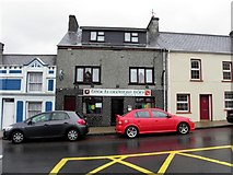 Teach Owenie BánPub · 4.3 mi
Explorer Tom Teach Owenie Bán in Dungloe has a sign that’s falling off the wall, which is very on-brand for the pub. The Irish name is fancy, but the pints are likely mediocre. Keep an eye out for ghosts.
 Inis Mhic an DoirnIsland · 4.4 mi
Explorer Tom Inis Mhic an Doirn has that 'don't touch' energy radiating off it like Wi-Fi. There’s a derelict building nearby that looks haunted by bad decisions. Mind the nettles, they're the real guards here and they bite back.
 InishkeelIslet · 4.5 mi
Explorer Tom Inishkeel has old churches and carved cross slabs, which sounds like a fine island hunt to me. Then Heritage Ireland stops me at the first step: it says the island is inaccessible to the public. An old low-tide crossing story is not a current invitation.
 Narin–Portnoo StrandOfficial bathing water · 5.0 mi
Explorer Tom Narin–Portnoo Strand is a cove with grand ambitions: about two kilometres of sand and a dune ridge behind it. Dunmore Head takes some of the Atlantic’s edge, while Inishkeel sits out front like it reserved the best seat. I would keep that island on my map, with the tide as its own boss.
 Drumlaghdrid HillMountain / peak · 5.1 mi
Explorer Tom Drumlaghdrid Hill stands in County Donegal with its access details currently unknown. A photograph shows the B7905 road climbing south-eastwards across its flank, six kilometres north of Lettermacaward. It is a bit cheeky for a hill to have such a well-documented road climbing up its side while still keeping its own path a secret!
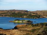 Doon FortFairy fort / stone ringfort · 5.8 mi
Explorer Tom Doon Fort in Drumboghill sits on an island like it’s got nowhere to be. Locals call it O'Boyle's Fort, which sounds fancy until you realise they were just hiding from their nosy neighbours back then.
More historic places in County Donegal · All of County Donegal

What do you know about this place?Tap to add a comment or ask a question