What is recorded here
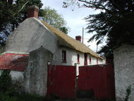
Detached five-bay single-storey whitewashed thatched direct-entry house, built c. 1800. Rectangular-plan, located perpendicular to road, lean-to corrugated-iron roofed outbuilding to west, forming part of boundary wall to road. Pitched oaten straw thatched roof, with comb of bobbins to the ridge, and hazel/willow rod scalloped into lower edge of roof to further secure eaves. Evidence of original pegs on west gable wall. Painted rendered coping to gables, redbrick chimneystacks and overhanging eaves. Whitewashed walling. Square-headed window openings, painted rendered soffits and reveals, painted stone sills, painted timber two-over-two sliding sash windows. Square-headed door openings, painted rendered soffits, reveals and surrounds, painted timber sheeted doors. Set perpendicular to road, with outbuilding occupying eastern end of the dwelling and large corrugated-iron shed set at right angle to house forming yard to west and south respectively. Whitewashed random rubble wall to west, square gate piers with smooth rendered pyramid cap, painted vertically-sheeted timber gates.
An important component of the vernacular tradition in County Louth, as identified by the informal arrangement of the openings together with the thatched roof, this house has been well maintained, retaining its original form and character. Its modest form is enhanced by the continued use of sash windows. The close proximity of its outbuildings is a reflection of vernacular farming traditions.
This does not grant access. Most recorded buildings are privately owned; view them only from public ground unless the owner allows entry.
Places near here
 Enclosure in BenaghEnclosure · 754 yd
 Cliff-edge fort in CastletowncooleyCliff-edge fort · 1022 yd
 IndicatedBawn · 1241 yd
 Piedmont Ho. (in ruins)House, 17th century · 1255 yd
 R.C. ChapelChurch · 1333 yd
 Cooley CastleCastle, tower house · 1591 yd
 SlievenagloghMountain / peak · 1.1 mi
 Grange UpperMountain / peak · 1.3 mi
 The BushPicnic place · 2.1 mi
 Carlingford - Loop 1A- Commons LoopWalking route · 2.4 mi
 Carlingford - Slieve Foye LoopWalking route · 2.6 mi
 Carlingford Heritage CentreVisitor information · 2.7 mi
Other information
Photo: National Inventory of Architectural Heritage · Website use allowed for educational or private purposes with source credit