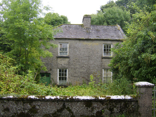
What is recorded here
Detached two-storey house, built c.1780, having three-bay ground floor and two-bay first floor to front (north-west) elevation. Now vacant. Pitched slate roof, hipped to north-east, with rendered chimneystack. Roughcast rendered walls. Square-headed window openings with cut-stone sills and timber sliding sash windows,…
Read the whole record
From the Buildings of Ireland (National Inventory of Architectural Heritage) record 30410607
Places near here
Picture notes
- Computer-made picture. It does not show this monument.
- National Inventory of Architectural Heritage
- Computer-made picture. It does not show this playground.
 Fairy fort / earthen ringfort in BallydavidFairy fort / earthen ringfort · 224 ydComputer-made picture
Explorer Tom Fairy fort / earthen ringfort in Ballydavid is an oval rath, which means it’s not perfectly round like a proper circle should be. There’s probably a dog in charge of it that barks at the cows. Go on a wet day, it suits the mood and your muddy boots.
 Fulacht fia in BallydavidFulacht fia · 261 ydComputer-made picture
Explorer Tom Fulacht fia in Ballydavid is an ancient cooking pit that claims to be older than your car, and honestly, it might be right. Take a breath of that air, it's older than your car.
 Man-made underground passage in BallynahistilMan-made underground passage · 540 ydComputer-made picture
Explorer Tom Man-made underground passage in Ballynahistil was likely the escape plan for some ancient lord who ran out of patience with his family. He probably slipped out the back while everyone was arguing about dinner. Grand place for a sulk or a snog, entirely your call to make.
 Field boundary in BallynahistilField boundary · 573 ydComputer-made picture
Explorer Tom Field boundary in Ballynahistil is a simple line in the earth that allegedly hides a tunnel straight to the local pub. It’s probably just a ditch, but who wants the truth when you have a story? Stand still and listen, because the wind tells it better than I ever could.
 Fairy fort / earthen ringfort in BallynahistilFairy fort / earthen ringfort · 588 ydComputer-made picture
Explorer Tom This Ballynahistil fort is barely a whisper of a bank, visible only in patches. It’s so low-key I’d need a magnifying glass to see the ditch. Hum something sad nearby, it adds atmosphere.
 Settlement desertedSettlement deserted, medieval · 1126 ydComputer-made picture
Explorer Tom Settlement deserted in Kilcooly is playing hide-and-seek with me. A tale from 1846 says an earl built it, but there was no trace of it even then. Take a picture for me if you pass!
 Field system in KilcoolyField system · 1149 ydComputer-made picture
Explorer Tom Field system in Kilcooly was managed by a matchmaker who paired off cows based on their horns. It’s basically a grid of ancient relationships gone wrong. Tell the kids it's a castle, close enough for them to believe it for an hour.
 Ballydoogan HouseBridge · 1201 yd
Explorer Tom Ballydoogan’s White Bridge is where a priest once lost a bet about the stone quality. It looks too fancy for its own good, showing off that technical engineering merit. If anyone asks, Tom sent his regards.
 Graveyard1216 ydComputer-made picture
Explorer Tom Graveyard in Kilcooly is hosting a very quiet party with zero invitees. The concrete wall looks like it’s judging your outfit from 1890. Grand place for a sulk or a snog, your call.
 Cooleeny WellWell · 1285 ydComputer-made picture
Explorer Tom Cooleeny Well is hiding in plain sight, probably drinking tea with its friends. Nobody knows exactly what’s down there, so don’t ask too many questions. A handy spot to stretch your legs and your imagination.
 DartfieldGate lodge · 1.2 mi
 Children's playground3.1 miComputer-made picture
More historic places in County Galway · All of County Galway

What do you know about this place?Tap to add a comment or ask a question