Overview
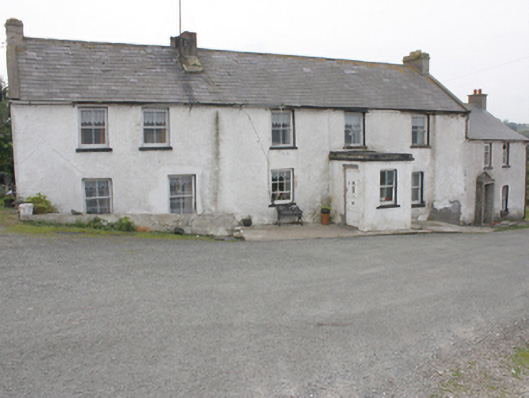
house — Arderly is recorded as house in Donegal. Attached five-bay two-storey house, built c. 1860, with projecting single-bay single-storey entrance porch to front elevation, modern two-storey return and single-storey extension to rear. Pitched slate roof with gable coping, smooth rendered chimneystacks, smooth rendered brick eaves course, and cast-iron rainwater goods.
Why it was built
The saved account records: Attached five-bay two-storey house, built c. 1860, with projecting single-bay single-storey entrance porch to front elevation, modern two-storey return and single-storey extension to rear.
People and work
The saved account records: Pitched slate roof with gable coping, smooth rendered chimneystacks, smooth rendered brick eaves course, and cast-iron rainwater goods.
How it changed
The saved account records: Square-headed window openings with two-over-two, six-over-three and one-over-one horned timber sash-windows with painted stone sills
What survives
The saved account records: Single-storey outbuildings to east comprising of corrugated-metal roofs and random rubble walls.
Why it mattered
house — Arderly matters for the exact reasons given in its official assessment, rather than merely because it is an old structure. The source records: An attractive early to mid-nineteenth century house, which retains its architectural integrity and form. The survival of the original slate roof and timber sash windows enhance its architectural heritage merit. A small mill settlement named Tremone with a large mill pond is shown on the Ordnance Survey first edition six-inch map of c. 1837. However this building appears to be later and is shown on the Ordnance Survey twenty-five inch map series (1888-1913) and the settlement is renamed as Arderly. The renaming probably coincided with the building of the nearby former Coastguard Station. This explains what the place adds to local life, the street or the surviving built history.
History checked 15 August 2026 against the named sources below.
Places near here
- Carrowbeg Children's Burial Groundmonumentunder 0.1 miles
- Tremone Baybeach0.2 miles
- D'Arcy Magee Walkwalk0.5 miles
- house — Ballymagaraghybuilding0.5 miles
- Ballycharry Walled Burial Ground and Cairnmonument0.5 miles
- Ballycharry Burial Cairnmonument0.5 miles
- Cross-inscribed pillar (present location) in Drumaville (tremone Ed)monument0.5 miles
- outbuilding — Ballymagaraghybuilding0.5 miles
- Drumaville Cairnmonument0.5 miles
- Cross-inscribed pillar in Drumaville (tremone Ed)monument0.5 miles
- outbuilding — Drumavillebuilding0.6 miles
- house — DRUMAVILLE (TREMONE)building0.6 miles
Add the human story, a picture, a first-hand message or a missing place.
Earn 5 points after the picture is checked and accepted.
Add a pictureAdd its storyTalk or ask a questionAdd a new placeThis official record and map point do not grant access. Most recorded buildings are privately owned; view them only from public ground unless the owner allows entry.
Conversation about this place
Questions and messages sit beneath the source record. They are checked before appearing.
No questions or messages yet.
Ask a question or join the conversation