What is recorded here
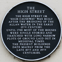
This black commemorative plaque records: The High Street or 'High Causeway' was built after the bridging of the Allan Water in the early 15th Century. Until 1700 most of the houses were single storied and thatched with long narrow plots of ground laid out in medieval times. The present buildings date mainly from the late 18th and 19th Centuries.
High Causeway, originally known as High Street, was constructed following the bridging of the Allan Water in the early 15th Century, marking a significant development in local infrastructure and urban layout that shaped the area's medieval to modern architectural evolution.
A plaque record does not grant entry to a building or private land. View it from a public place unless permission is clearly given.
Places near here
 Dunblane, Stirling Road, Stirling Arms HotelHotel (18th Century) · 36 yd
 Dunblane, Stirling Road, Dunblane BridgeRoad Bridge (15th Century) · 46 yd
 Allanside HouseMemorial · 64 yd
 Dunblane, MillrowUnidentified Pottery (medieval) · 105 yd
 Leighton LibraryMuseum · 235 yd
 DunblaneSocketed Axehead (bronze)(period Unassigned) · 242 yd
 Dunblane MuseumMuseum · 292 yd
 War MemorialMemorial · 402 yd
 The Allan WaterVisitor information · 666 yd
 Dunblane, Stirling RoadNo Class (event) (21st Century) · 743 yd
 Dunblane school massacremass murder · 756 yd
 Hungryhill WoodWood · 1422 yd
Other information
Photo: Brian Cooper · CC BY 2.0