Places near here
Photo credits
- Anne Burgess, Wikimedia Commons · CC BY-SA 2.0
- Colin Park, Geograph · CC BY-SA 2.0
- George McHugh, Geograph · CC BY-SA 2.0
- Mick Garratt, Wikimedia Commons · CC BY-SA 2.0
- Victuallers, Wikimedia Commons · CC BY-SA 4.0
- Copernicus Sentinel-2, ESA, Wikimedia Commons · CC BY-SA 3.0 igo
- Chris Burrell, Wikimedia Commons · Creative Commons Attribution-ShareAlike 2.0
- S. M'S., Wikimedia Commons · Public domain
- Eric Jones, Geograph · CC BY-SA 2.0
- Kenneth Allen, Wikimedia Commons · CC BY-SA 2.0
- Bob Embleton, Geograph · Creative Commons Attribution-ShareAlike 2.0
- Mat Tuck, Geograph · CC BY-SA 2.0
 Rue Point LighthouseLighthouse · 807 yd
Explorer Tom Rue Point Lighthouse claims to be three thousand years old, which I think is a lie, but I’m not going to correct it in front of the gulls. It’s sitting on the southern tip looking smug, probably because it has the best view of the ocean and no one to share it with. Best seen with a hangover and a sausage roll.
 Rue PointHeadland · 826 yd
Explorer Tom Rue Point was nearly sold off to a farmer for one horse and a bag of potatoes in 1820. Luckily, the farmer changed his mind when the point refused to be moved to a paddock. Pretend you're a lost aristocrat, nobody will check.
 Ushet PointHeadland · 860 yd
Explorer Tom Ushet Point gave up meat for Lent but ended up eating fish, which it claims doesn't really count as cheating. It’s a headland with a sense of humor, standing there while the weather tries to ruin its day. Bring a flask of something warm and a story to swap.
 Kelp Store1.7 mi
Explorer Tom Kelp Store on Rathlin Island is basically a giant closet that stores seaweed like it’s storing state secrets. It’s been doing this for so long the kelp might be considered family now. Stick around for the light changing, it's a show you can't buy tickets for.
 Boathouse Visitor Centre & MuseumMuseum · 1.9 mi
Explorer Tom Boathouse Visitor Centre & Museum in County Antrim has a secret talent for making you feel like you’ve forgotten something important immediately. It’s got that nautical charm that works well even when you’re dry land. Walk past slowly like you're in a film.
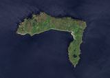 Rathlin IslandIsland · 1.9 mi
Explorer Tom Rathlin Island smells like fresh air mixed with old boats and ambition, according to my highly trained nose. The Sentinel-2 photos make it look like a pixelated green blob, but in person, it’s got real character. It’s not just an island; it’s a statement of stubbornness. Best enjoyed with a bag of chips and no plans.
 Fortification: bruce's castle in BallycarryFortification: Bruce's Castle · 2.5 mi
Explorer Tom Fortification: bruce's castle in Ballycarry claims royal blood but looks like a tired old garden gnome. Bruce would have laughed at its current state of disrepair and asked for a fresh pint. If it's closed, admire it from the road like a polite stalker.
 Rathlin CastleRuins · 2.6 mi
Explorer Tom Rathlin Castle in County Antrim has heard the opinion of the local sheep, who all agree that it’s too drafty for comfort. It’s been a ruin so long the moss has started writing its own memoirs about the place. Ideal place to rehearse an excuse for being late.
 Ballycarry Trail, RathlinWalking route · 2.6 mi
Explorer Tom Ballycarry Trail, Rathlin in County Antrim is said to have hosted a fiddler who played until the sun came up. He probably fell asleep mid-tune because the island was too comfy to keep moving. Go back in winter, it's a different animal.
 Cranagh IslandIslet · 3.8 mi
Explorer Tom Cranagh Island would post on social media saying 'Vibes are wet today' and get ten thousand likes. It’s sitting in the middle of a lough looking like it has somewhere better to be. The stilt houses are just wooden feet trying to keep up with fashion. Ten minutes here and you'll have a yarn for the pub.
 Crannog in Lough Na Cranagh in CrossCrannog in Lough Na Cranagh · 3.8 mi
Explorer Tom Crannog in Lough Na Cranagh was saved by a hero nobody remembers who probably just wanted to get away from his wife’s cooking. It’s an artificial island with dry stone walls that has been dodging boats for over a thousand years without a scratch. Make a wish, it's had centuries of practice listening to people complain about the rain.
 Ballycastle BeachBeach / strand · 4.2 mi
Explorer Tom Ballycastle Beach has a bad poem about it that rhymes 'sand' with 'band' and no one likes it. The golf course next door thinks this is very exclusive, which is rich coming from sand. A good place to forget your phone for ten minutes.
More wrecks and historic events in County Antrim · All of County Antrim

What do you know about this place?Tap to add a comment or ask a question