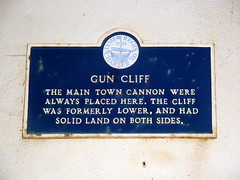
What is recorded here
This blue commemorative plaque records: Gun Cliff The main town cannon were always placed here. The cliff was formerly lower, and had solid land on both sides. Recorded plaque organisation: Lyme Regis Charter 700.
Gun Cliff served as the primary location for mounting the town's defensive cannon, indicating its strategic importance in local defense historically; the site's elevation and position suggest it played a crucial role in safeguarding the area from maritime threats.
A plaque record does not grant entry to a building or private land. View it from a public place unless permission is clearly given.
Places near here
 Lyme Regis MuseumMuseum · 14 yd
 The MuseumListed building · 17 yd
 Guildhall CottageListed building · 24 yd
 War MemorialMemorial · 114 yd
 Church Cliff BeachBeach / strand · 138 yd
 Town Mill MalthouseGallery · 138 yd
 A sort of wishing wellOld or holy well · 160 yd
_-_geograph.org.uk_-_7186122.jpg?width=1280) Mary AnningVisitor information · 172 yd
Mary AnningVisitor information · 172 yd Monmouth BeachBeach / strand · 1088 yd
 Devonshire HeadCliff · 1518 yd
 Chimney RockViewpoint · 1.1 mi
 Old Milestone by the former A35, CharmouthMonument or public art · 1.5 mi
Other information
Photo: Simon Harriyott · CC BY 2.0