Places near here
Photo credits
- National Inventory of Architectural Heritage
- Public picture contributor, Wikimedia Commons · CC BY-SA 3.0
- N Chadwick, Geograph · CC BY-SA 2.0
- Turkishbob at English Wikipedia, Wikimedia Commons · CC BY 2.5
- N Chadwick, Wikimedia Commons · CC BY-SA 2.0
- John Lucas, Geograph · CC BY-SA 2.0
- Night of the Big Wind, Wikimedia Commons · CC BY-SA 3.0 nl
- Kiran Madhusudhanan, Wikimedia Commons · CC BY-SA 4.0
- Colin Park, Geograph · CC BY-SA 2.0
 Saddle Hill Signal TowerSignal tower · 1.1 mi
Explorer Tom Saddle Hill Signal Tower is just a pile of rocks pretending to be architecture. It used to shout messages to ships, but…
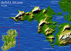 Deserted VillageHeritage attraction · 1.2 mi
Explorer Tom The Deserted Village stretches along the slopes of Slievemore on Achill, a line of roofless stone cottages that can…
 The Deserted Village at SlievemoreVisitor information · 1.2 mi
Explorer Tom The Deserted Village at Slievemore is haunted by ghosts who are mostly just annoyed about the lack of broadband, but…
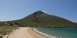 SlievemoreMountain / peak · 1.5 mi
Explorer Tom Slievemore rises over Achill Island with a long stony shoulder above a roofless village. From below, the old houses…
 Achill HengeInstallation · 2.2 mi
Explorer Tom Achill-henge looks ancient from the wrong angle, which is exactly why I should tell you the date before inventing a…
 Convent of the Sacred HeartConvent/nunnery · 2.7 mi
Explorer Tom Convent of the Sacred Heart in Keel East is guarding a legend about a giant who slept in the garden. The sisters…
 Dooagh StrandBeach / strand · 2.9 mi
Explorer Tom Dooagh Strand on Achill pulled off a magic trick and took it away again. Its sand vanished in the 1980s, returned in…
 Doogort BeachBeach / strand · 2.9 mi
Explorer Tom Doogort Beach, on Achill Island's north shore, has a mountain at its back and Blacksod Bay in front, as if someone gave…
 IndicatedCrannog · 3.6 mi
Explorer Tom Crannog in Dookinelly is the shortcut that isn’t a shortcut because it involves wading through mud and regret. It’s an…
 Wild Atlantic Way:Visitor information · 4.1 mi
Explorer Tom Another Wild Atlantic Way? Right, so this one would complain to the council that the clouds keep stealing its spotlight…
 Achill Island - AcaillIsland · 4.1 mi
Explorer Tom If I say Achill is a quick detour, hide my car keys. Achill is Ireland's largest island, yet you can arrive without…
 Croaghaun sw TopMountain / peak · 4.9 mi
Explorer Tom Croaghaun sw Top was saved by a hero nobody remembers, who probably just stopped looking in the wrong direction for…
More cliffs, bays and coast in County Mayo · All of County Mayo

What do you know about this place?Tap to add a comment or ask a question