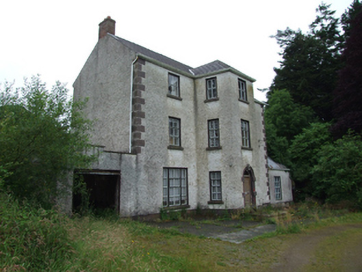
What is recorded here
Detached three-bay three-storey house, built c.1750, with Gibbsian doorcase in canted central bay, single-storey addition to north-west gable, single-storey lean-to along rear elevation. Now disused. Pitched artificial slate roof with hipped section over central projection, replacement brick chimneys to gables and uPVC rainwater goods. Replacement wet-dash cement render with raised quoins and smooth plinth. Graduated window openings with enlarged openings to ground floor, narrower windows to sides of central projection, all having stone sills and replacement aluminium windows. Internal flat-panelled timber shutters to front windows. Round-headed entrance with stone Gibbsian surround comprising blocked architrave with archivolt and flat keystone, replacement panelled door and fanlight, opening to stone steps around three sides. Single- and two-storey outbuildings to rear yard with pitched slate roofs, rendered rubble stone walls, timber lintels above sash windows and timber sheeted doors. Outbuildings to the south with barrel corrugated-iron roof, rubble-stone walls, square openings and arched openings with stone voussoirs. Square-profile stone piers and replacement metal gates to entrance.
A substantial three-storey Classical house of the middle size, retaining its historic form and some significant details, including a blocked Gibbsian door surround, a classic feature of this type. The front elevation has a strong architectural presence emphasised by the projecting three-storey central bay with splayed sides and is softened by a slight asymmetry. The Ordnance Survey map of 1909 shows the house once had bowed wings, now demolished. The width of the ground floor window openings indicates that these may have been widened to accommodate tripartite Wyatt windows around 1800.
From the Buildings of Ireland (National Inventory of Architectural Heritage) record 40401417
This does not grant access. Most recorded buildings are privately owned; view them only from public ground unless the owner allows entry.
Places near here
 Church in ruinsReligious house, Augustinian canons · 1243 yd
 Drumlane AbbeyHeritage attraction · 1281 yd
 Saint Patrick's Catholic ChurchChurch/chapel · 1403 yd
 Putiaghan Lower ForestForest · 2.6 mi
 Pedunculate Oak2.9 mi
 Belturbet Railway Station Visitor CentreHeritage attraction · 3.3 mi
 Welcome to Belturbet StationVisitor information · 3.3 mi
 Mill WalkVisitor information · 3.3 mi
 Clogh Oughter CastleCastle, Anglo-Norman masonry castle · 3.4 mi
 Court tomb in GartnanoulCourt tomb · 3.5 mi
 Evlagh MoreMountain / peak · 4.0 mi
.jpg/250px-Doon_(0).jpg "Photo: Wanfried-Dublin, Wikimedia Commons · CC0") Court tomb in Doon (ballyconnell Ed)Court tomb · 5.4 mi
Court tomb in Doon (ballyconnell Ed)Court tomb · 5.4 miPictures: Oliver Dixon, Wikimedia Commons · CC BY-SA 2.0; Deadstar, Wikimedia Commons · CC BY-SA 4.0; Kenneth Allen, Geograph · CC BY-SA 2.0; Algirdas at Lithuanian Wikipedia, Wikimedia Commons · Public domain; Adam Simpson, Geograph · CC BY-SA 2.0; NTF30, Wikimedia Commons · CC BY-SA 4.0; Wanfried-Dublin, Wikimedia Commons · CC0
More historic places in County Cavan · All of County Cavan
What do you know about this place?